WRF Bibliography
My publications, talks, and other public material
2022
- W. Randolph Franklin and Salles Viana Gomes de Magalhães.
Implementing simulation of simplicity for geometric degeneracies.
In 4th ACM SIGSPATIAL International Workshop on Spatial Gems (SpatialGems 2022). 1 Nov 2022.
[abstract▼] [details] [full text] [BibTeX▼] - Marcelo de Matos Menezes, Salles Viana Gomes Magalhães, Matheus Aguilar de Oliveira, W. Randolph Franklin, and Rodrigo Eduardo de Oliveira Bauer Chichorro.
Fast parallel evaluation of exact geometric predicates on GPUs.
J. Computer Aided Design, September 2022.
Special Issue: 28th International Meshing Roundtable: Mesh Modeling for Simulations and Visualization.
URL: https://www.sciencedirect.com/science/article/abs/pii/S0010448522000616, doi:https://doi.org/10.1016/j.cad.2022.103285.
[abstract▼] [details] [full text] [BibTeX▼] - Marcelo de Matos Menezes, Salles Viana Gomes de Magalhães, Matheus Aguilar, W. Randolph Franklin, and Bruno Coelho.
Employing GPUs to accelerate exact geometric predicates for 3D geospatial processing.
In John Krumm, Andreas Züfle, and Cyrus Shahabi, editors, Spatial Gems, volume 1, chapter 11.
ACM, 2022.
URL: https://www.spatialgems.net/.
[abstract▼] [details] [full text] [BibTeX▼] - W. Randolph Franklin and Salles Viana Gomes de Magalhães.
Minimal representations of polygons and polyhedra.
In John Krumm, Andreas Züfle, and Cyrus Shahabi, editors, Spatial Gems, volume 1, chapter 5.
ACM, 2022.
URL: https://www.spatialgems.net/.
[abstract▼] [details] [full text] [BibTeX▼]
2021
- W. Randolph Franklin, Salles Viana Gomes de Magalhães, and Eric N Landis.
Fast 3-D Euclidean connected components.
In John Krumm, editor, 3rd ACM SIGSPATIAL International Workshop on Spatial Gems (SpatialGems 2021).
ACM, 2 Nov 2021.
URL: https://www.spatialgems.net/.
[abstract▼] [details] [full text] [BibTeX▼]
2020
- Marcelo de Matos Menezes, Salles Viana Gomes de Magalhães, Matheus Aguilar, W. Randolph Franklin, and Bruno Coelho.
Employing GPUs to accelerate exact geometric predicates for 3D geospatial processing.
In John Krumm, editor, 2nd ACM SIGSPATIAL International Workshop on Spatial Gems (SpatialGems 2020).
ACM, Nov 2020.
URL: https://www.spatialgems.net/.
[abstract▼] [details] [full text] [BibTeX▼] - Marcelo de Matos Menezes, Salles Viana Gomes de Magalhães, Matheus Aguilar, W. Randolph Franklin, and Bruno Coelho.
Employing GPUs to accelerate exact geometric predicates for 3D geospatial processing.
In John Krumm, editor, 2nd ACM SIGSPATIAL International Workshop on Spatial Gems (SpatialGems 2020).
ACM, Nov 2020.
URL: https://www.spatialgems.net/.
[abstract▼] [details] [full text] [BibTeX▼] - W. Randolph Franklin, Salles Viana Gomes de Magalhães, and Wenli Li.
Siting thousands of radio transmitter towers on terrains with billions of points.
2020.
arXiv 2006.16783.
arXiv:2006.16783.
[abstract▼] [details] [full text] [BibTeX▼] - Salles V. G. de Magalhães, W. Randolph Franklin, and Marcus V. A. Andrade.
An efficient and exact parallel algorithm for intersecting large 3-d triangular meshes using arithmetic filters.
J. Computer Aided Design, March 2020.
online 2019-12-19.
doi:https://doi.org/10.1016/j.cad.2019.102801.
[abstract▼] [details] [full text] [BibTeX▼]
2019
- W. Randolph Franklin and Salles Viana Gomes de Magalhães.
Minimal representations of polygons and polyhedra.
In John Krumm, editor, 1st ACM SIGSPATIAL International Workshop on Spatial Gems (SpatialGems 2019).
ACM, Nov 2019.
URL: https://www.spatialgems.net/.
[abstract▼] [details] [full text] [BibTeX▼] - Marcelo de Matos Menezes, Salles Viana Gomes Magalhães, W. Randolph Franklin, Matheus Aguilar de Oliveira, and Rodrigo E. O. Bauer Chichorro.
Accelerating the exact evaluation of geometric predicates with GPUs.
In Suzanne Shontz, Joaquim Peiró, and Ryan Viertel, editors, 28th International Meshing Roundtable. Buffalo, NY, USA, 16 Oct 2019.
doi:10.5281/zenodo.3653101.
[abstract▼] [details] [full text] [slides] [BibTeX▼] - W. Randolph Franklin and Salles V. G. de Magalhães.
Computing intersection areas of overlaid 2d meshes.
In IGS2019 International Geometry Summit Posters' proceedings. Vancouver, Canada, 17–21 June 2019. Solid Modeling Association.
[abstract▼] [details] [full text] [poster] [fastforward] [BibTeX▼]
2018
- Salles Viana Gomes de Magalhães, W. Randolph Franklin, and Ricardo dos Santos Ferreira.
Fast analysis of upstream features on spatial networks (GIS Cup).
In Proceedings of the 26th ACM SIGSPATIAL International Conference on Advances in Geographic Information Systems, SIGSPATIAL '18, 622–625. New York, NY, USA, 2018. ACM.
Winner (1st place).
doi:https://doi.org/10.1145/3274895.3276474.
[abstract▼] [details] [full text] [slides] [BibTeX▼] - W. Randolph Franklin, Salles V. G. de Magalhães, and Marcus V. A. Andrade.
Data structures for parallel spatial algorithms on large datasets (vision paper).
In Proceedings of BigSpatial'18: 7th ACM SIGSPATIAL Workshop on Analytics for Big Geospatial Data. Seattle, USA, 6 Nov 2018.
[abstract▼] [details] [full text] [slides] [BibTeX▼] - W. Randolph Franklin, Salles V. G. de Magalhães, and Marcus V. A. Andrade.
Exact fast parallel intersection of large 3-D triangular meshes (extended abstract).
In 28th Annual Fall Workshop on Computational Geometry. Queens College, CUNY, New York City, 26–27 Oct 2018.
[abstract▼] [details] [full text] [BibTeX▼] - W. Randolph Franklin, Salles V. G. de Magalhães, and Marcus V. A. Andrade.
Exact fast parallel intersection of large 3-D triangular meshes.
In 27th International Meshing Roundtable. Alberqueque, New Mexico, 2 Oct 2018.
[abstract▼] [details] [full text] [slides] [BibTeX▼] - W. Randolph Franklin and Carlos Varela.
Intelligent cognitive assistant for emergency landings using gpu geometric computing and online statistical reasoning.
unpublished, 2018.
[abstract▼] [details] [full text] [BibTeX▼]
2017
- W. Randolph Franklin.
Applications of geometry.
In Kenneth H Rosen, editor, Handbook of Discrete and Combinatorial Mathematics, Discrete Mathematics and Its Applications, chapter 13.8, pages 998–1022.
CRC Press, 2nd edition, 1 Dec 2017.
[abstract▼] [details] [full text] [BibTeX▼] - W. Randolph Franklin and Salles V. G. de Magalhães.
Parallel intersection detection in massive sets of cubes.
In 27th Fall Workshop on Computational Geometry. Stony Brook University, New York, USA, 3–4 Nov 2017.
(talk).
[abstract▼] [details] [slides] [BibTeX▼] - W. Randolph Franklin and Salles V. G. de Magalhães.
Parallel intersection detection in massive sets of cubes.
In Proceedings of BigSpatial'17: 6th ACM SIGSPATIAL Workshop on Analytics for Big Geospatial Data. Los Angeles Area, CA, USA, 7-10 Nov 2017.
doi:https://doi.org/10.1145/3150919.3150921.
[abstract▼] [details] [full text] [slides] [BibTeX▼] - Salles V. G. de Magalhães, W. Randolph Franklin, and Marcus V. A. Andrade.
Fast exact parallel 3D mesh intersection algorithm using only orientation predicates.
In 25th ACM SIGSPATIAL International Conference on Advances in Geographic Information Systems (ACM SIGSPATIAL 2017). Los Angeles Area, CA, USA, 7–10 Nov 2017.
[abstract▼] [details] [full text] [slides] [BibTeX▼] - W. Randolph Franklin, Salles V. G. de Magalhães, and Marcus V. A. Andrade.
3D-EPUG-Overlay: intersecting very large 3D triangulations in parallel.
In 2017 SIAM conference on industrial and applied geometry. Pittsburgh PA USA, 10–12 July 2017.
(talk).
[abstract▼] [details] [slides] [BibTeX▼] - W. Randolph Franklin, Salles V. G. de Magalhães, and Marcus V. A. Andrade.
An exact and efficient 3D mesh intersection algorithm using only orientation predicates.
In S3PM-2017: International Convention on Shape, Solid, Structure, & Physical Modeling, Shape Modeling International (SMI-2017) Symposium. Berkeley, California, USA, 19–23 June 2017.
(poster).
[abstract▼] [details] [poster] [BibTeX▼] - Wenli Li and W. Randolph Franklin.
GPU–accelerated multiple observer siting.
Photogrammetric Engineering & Remote Sensing, 83(6):439–446, June 2017.
doi:https://doi.org/10.14358/PERS.83.6.439.
[abstract▼] [details] [full text] [BibTeX▼]
2016
- Maurício Gouvêa Gruppi, Salles V. G. de Magalhães, Marcus V. A. Andrade, W. Randolph Franklin, and Wenli Li.
Using rational numbers and parallel computing to efficiently avoid round-off errors on map simplification.
RBC. Revista Brasileira de Cartografia (Online), 68:1221–1230, 2016.
online at \url http://www.lsie.unb.br/rbc/index.php/rbc/article/view/1857.
[abstract▼] [details] [full text] [BibTeX▼] - W. Randolph Franklin.
Efficient parallel GIS and CAD operations on very large data sets.
31 Oct 2016.
Invited keynote talk at ACM SIGSPATIAL GIS PhD Workshop.
[details] [slides] [BibTeX▼] - Salles V. G. de Magalhães, Marcus V. A. Andrade, W. Randolph Franklin, Wenli Li, and Maurício Gouvêa Gruppi.
Exact intersection of 3D geometric models.
In Geoinfo 2016, XVII Brazilian Symposium on GeoInformatics. Campos do Jordão, SP, Brazil, November 2016. Instituto Nacional de Pesquisas Espaciais (Brasil).
[abstract▼] [details] [full text] [slides] [BibTeX▼] - Wenli Li, W. Randolph Franklin, and Salles V. G. de Magalhães.
Computing approximate horizons on a GPU.
In 26th Fall Workshop on Computational Geometry. CUNY Graduate Center, New York, USA, 27-28 Oct 2016.
(extended abstract).
[abstract▼] [details] [full text] [slides] [BibTeX▼] - Salles Viana Gomes de Magalhães, W. Randolph Franklin, Wenli Li, and Marcus Vinicius Alvim Andrade.
An efficient map-reduce algorithm for spatio-temporal analysis using spark (GIS Cup).
In 5th GIS-focused algorithm competition, GISCup 2016, co-located with ACM SIGSPATIAL GIS. 2016.
Winner (2nd place).
[abstract▼] [details] [full text] [slides] [BibTeX▼] - Wenli Li, W. Randolph Franklin, Salles V. G. de Magalhães, Marcus V. A. Andrade, and David L. Hedin.
3D segmented ODETLAP compression.
2016.
[abstract▼] [details] [full text] [BibTeX▼] - David Hedin and W. Randolph Franklin.
Nearptd: a parallel implementation of exact nearest neighbor search using a uniform grid.
In Canadian Conference on Computational Geometry. Vancouver Canada, August 2016.
[abstract▼] [details] [full text] [slides] [BibTeX▼] - W. Randolph Franklin.
Minimum spatial representations.
2016.
(unpublished).
[abstract▼] [details] [full text] [BibTeX▼] - Salles V. G. de Magalhães, Marcus V. A. Andrade, W. Randolph Franklin, and Wenli Li.
PinMesh – Fast and exact 3D point location queries using a uniform grid.
Computer & Graphics Journal, special issue on Shape Modeling International 2016, 58:1–11, August 2016.
(online 17 May). Awarded a reproducibility stamp, \url http://www.reproducibilitystamp.com/.
URL: http://www.sciencedirect.com/science/article/pii/S0097849316300607, doi:https://doi.org/10.1016/j.cag.2016.05.017.
[abstract▼] [details] [full text] [slides] [BibTeX▼] - Chaulio R. Ferreira, Marcus V. A. Andrade, Salles V. G. de Magalhães, and W. Randolph Franklin.
An efficient external memory algorithm for terrain viewshed computation.
ACM Trans. on Spatial Algorithms and Systems, 2016.
doi:https://doi.org/10.1145/2903206.
[abstract▼] [details] [full text] [BibTeX▼] - W. Randolph Franklin and Salles Viana Gomes de Magalhães.
Local topology and parallel overlaying large planar graphs.
15 Feb 2016.
Talk at Georgia Tech, School of Interactive Computing. Also given at IBM Haifa, Microsoft Haifa, Ben Gurion U, and Tel Aviv U in Dec 2015.
[details] [slides] [BibTeX▼] - Max J Egenhofer, Keith C Clarke, Song Gao, Teriitutea Quesnot, W. Randolph Franklin, May Yuan, and David Coleman.
Contributions of GIScience over the past twenty years.
In Harlan Onsrud and Werner Kuhn, editors, Advancing Geographic Information Science: The Past and Next Twenty Years, chapter 1, pages 9–34.
GSDI association press, 2016.
[abstract▼] [details] [full text] [BibTeX▼] - Mehrad Kamalzare, Thomas F. Zimmie, Barbara Cutler, and W. Randolph Franklin.
A new visualization method to evaluate sediment transport and erosion.
Geotechnical Testing Journal, May 2016.
doi:https://doi.org/10.1520/GTJ20140226.
[abstract▼] [details] [full text] [BibTeX▼]
2015
- Mauricio G. Gruppi, Salles V. G. de Magalhães, Marcus V. A. Andrade, W. Randolph Franklin, and Wenli Li.
An efficient and topologically correct map generalization heuristic.
In Proceedings of the 17th International Conference on Enterprise Information Systems (ICEIS), 516–525, paper 236. 2015.
URL: http://www.iceis.org/Abstracts/2015/ICEIS_2015_Abstracts.htm, doi:https://doi.org/10.5220/0005398105160525.
[abstract▼] [details] [full text] [BibTeX▼] - W. Randolph Franklin and Salles Viana Gomes de Magalhães.
Global properties from local topology.
10 Nov 2015.
Talk at UC Santa Barbara, Center for Spatial Studies.
[details] [slides] [BibTeX▼] - Mehrad Kamalzare, Thomas F. Zimmie, Zhongxian Chen, Christopher Stuetzle, Barbara Cutler, and W Randolph Franklin.
Computer erosion modeling considering soil hydraulic conductivity.
Journal of Geotechnical and Transportation Engineering, 22 June 2015.
[details] [full text] [BibTeX▼] - Maurício Gouvêa Gruppi, Salles V. G. de Magalhães, Marcus V. A. Andrade, W. Randolph Franklin, and Wenli Li.
Using rational numbers and parallel computing to efficiently avoid round-off errors on map simplification.
In Geoinfo 2015, XVI Brazilian Symposium on GeoInformatics. Campos do Jordão, SP, Brazil, 29 Nov – 2 Dec 2015.
[abstract▼] [details] [full text] [slides] [BibTeX▼] - Salles V. G. de Magalhães, Marcus V. A. Andrade, W. Randolph Franklin, and Wenli Li.
Fast path planning under polygonal obstacle constraints.
In 4th GIS-focused algorithm competition, GISCUP 2015, co-located with ACM SIGSPATIAL GIS. Bellevue WA USA, 4 Nov 2015.
Winner (2nd place).
[details] [full text] [BibTeX▼] - Salles V. G. de Magalhães, Marcus V. A. Andrade, W. Randolph Franklin, and Wenli Li.
Fast path planning under polygonal obstacle constraints.
In 4th GIS-focused algorithm competition, GISCUP 2015, co-located with ACM SIGSPATIAL GIS. Bellevue WA USA, 4 Nov 2015.
[details] [full text] [BibTeX▼] - Salles V. G. de Magalhães, Marcus V. A. Andrade, W. Randolph Franklin, and Wenli Li.
Fast exact parallel map overlay using a two-level uniform grid.
In 4th ACM SIGSPATIAL International Workshop on Analytics for Big Geospatial Data (BigSpatial). Bellevue WA USA, 3 Nov 2015.
doi:https://doi.org/10.1145/2835185.2835188.
[abstract▼] [details] [full text] [BibTeX▼] - Wenli Li, W. Randolph Franklin, and Salles V. G. de Magalhães.
Segmented ODETLAP compression.
In 25th Fall Workshop on Computational Geometry. U. Buffalo, New York, USA, 23-24 Oct 2015.
(extended abstract).
[details] [full text] [BibTeX▼] - Salles V. G. de Magalhães, W. Randolph Franklin, Marcus V. A. Andrade, and Wenli Li.
An efficient algorithm for computing the exact overlay of triangulations.
In 25th Fall Workshop on Computational Geometry. U. Buffalo, New York, USA, 23-24 Oct 2015.
(extended abstract).
[details] [full text] [BibTeX▼] - W. Randolph Franklin, Marcus Andrade, Wenli Li, and Salles de Magalhães.
Changing problems, databases, and tools in spatial search.
24 Aug 2015.
Talk at U. Zürich, Dept of Geography.
[details] [slides] [BibTeX▼] - W. Randolph Franklin.
Algorithms, libraries, and development environments to process huge geoinformatic databases on modern hardware.
Talk at CCNY, 15 April 2015.
[details] [slides] [BibTeX▼] - Marcus Andrade, Salles de Magalhães, W. Randolph Franklin, and Wenli Li.
Research topics in GIS.
Talk at CCNY, 15 April 2015.
[details] [slides] [BibTeX▼] - Wenli Li, W. Randolph Franklin, Marcus Andrade, and Salles de Magalhães.
Research summary: siting and ODETLAP.
Talk at CCNY, 15 April 2015.
[details] [slides] [BibTeX▼] - Thiago L. Gomes, Salles V. G. de Magalhães, Marcus V. A. Andrade, W. Randolph Franklin, and Guilherme C. Pena.
Efficiently computing the drainage network on massive terrains with an external memory flooding process.
Geoinformatica, April 2015.
\url http://link.springer.com/article/10.1007/s10707-015-0225-y.
doi:https://doi.org/10.1007/s10707-015-0225-y.
[details] [full text] [BibTeX▼]
2014
- W. Randolph Franklin and Marcus Andrade.
The changing problems, databases, and tools in spatial search.
In University of California at Santa Barbara, Spatial Search Specialist Workshop. 8–9 Dec 2014.
[details] [full text] [slides] [BibTeX▼] - Salles V. G. de Magalhães, W. Randolph Franklin, Wenli Li, and Marcus V. A. Andrade.
Fast map generalization heuristic with a uniform grid.
In 22nd ACM SIGSPATIAL International Conference on Advances in Geographic Information Systems (ACM SIGSPATIAL 2014). Dallas, Texas, USA, 4–7 Nov 2014.
[details] [full text] [poster] [slides] [BibTeX▼] - Wenli Li, W. Randolph Franklin, Daniel N. Benedetti, and Salles V. G. de Magalhães.
Parallel multiple observer siting on terrain.
In 22nd ACM SIGSPATIAL International Conference on Advances in Geographic Information Systems (ACM SIGSPATIAL 2014). Dallas, Texas, USA, 4–7 Nov 2014.
[abstract▼] [details] [full text] [poster] [BibTeX▼] - Guilherme Pena, Salles de Magalhães, Marcus Andrade, Randolph Franklin, Chaulio Ferreira, Wenli Li, and Daniel Benedetti.
An efficient GPU multiple-observer siting method based on sparse-matrix multiplication.
In 3rd ACM SIGSPATIAL International Workshop on Analytics for Big Geospatial Data (BigSpatial) 2014. Dallas TX USA, 4 Nov 2014.
[abstract▼] [details] [full text] [slides] [BibTeX▼] - Salles V. G. de Magalhães, W. Randolph Franklin, Marcus V. A. Andrade, and Wenli Li.
An efficient map generalization heuristic based on the Visvalingam–Whyatt algorithm.
In 24th Fall Workshop on Computational Geometry. U. Connecticut, Storrs CT, USA, 31 Oct – 1 Nov 2014.
(extended abstract).
[details] [full text] [slides] [BibTeX▼] - Wenli Li, W. Randolph Franklin, Salles V. G. de Magalhães, and Marcus V. A. Andrade.
Restricted bathymetric tracklines interpolation.
In 24th Fall Workshop on Computational Geometry. U. Connecticut, Storrs CT, USA, 31 Oct – 1 Nov 2014.
(extended abstract).
[abstract▼] [details] [full text] [slides] [BibTeX▼] - Salles V. G. de Magalhães and W. Randolph Franklin.
Exactly computing map overlays using rational numbers.
In Autocarto 2014. Pittsburgh PA, 5–7 Oct 2014. Cartography and Geographic Information Society.
(abstract only).
[details] [full text] [slides] [BibTeX▼] - Chaulio R. Ferreira, Marcus V. A. Andrade, Salles V. G. de Magalhães, W. R. Franklin, and Guilherme C. Pena.
A parallel algorithm for viewshed computation on grid terrains.
Journal of information and data management, 2014.
invited.
[abstract▼] [details] [full text] [BibTeX▼] - Salles V. G. de Magalhães, Marcus V. A. Andrade, W. Randolph Franklin, and Guilherme C. Pena.
A linear time algorithm to compute the drainage network on grid terrains.
J. Hydroinformatics, 16(6):1227–1234, 2014.
Update of the winner of the Best Paper Award (2nd place) at AGILE 2012.
doi:https://doi.org/10.2166/hydro.2013.068.
[details] [full text] [BibTeX▼] - Guilherme C. Pena, Marcus V.A. Andrade, Salles V.G. de Magalhães, W. R. Franklin, and Chaulio R. Ferreira.
An improved parallel algorithm using GPU for siting observers on terrain.
In 16th International Conference on Enterprise Information Systems (ICEIS 2014), 367–375. Lisbon, 27–30 April 2014.
doi:https://doi.org/10.5220/0004884303670375.
[abstract▼] [details] [full text] [slides] [BibTeX▼]
2013
- W. Randolph Franklin.
Algorithms, libraries, and development environments to process huge geoinformatic databases on modern hardware.
Geoinfo 2013, XIV Brazilian Symposium on GeoInformatics, 26 Nov 2013.
Keynote talk, \url http://www.geoinfo.info/geoinfo2013/index.php.
[abstract▼] [details] [slides] [BibTeX▼] - Randolph Franklin.
Adaptive grids then and now.
In Barry Wellar, editor, AutoCarto Six Retrospective, pages 119–124.
Information Research Board Inc., 2013.
[details] [full text] [BibTeX▼] - Chaulio R. Ferreira, Marcus V. A. Andrade, Salles V. G. de Magalhães, W. R. Franklin, and Guilherme C. Pena.
A parallel sweep line algorithm for visibility computation.
In Geoinfo 2013, XIV Brazilian Symposium on GeoInformatics. Campos do Jordão, SP, Brazil, 24–27 Nov 2013.
Winner of best paper award, \url http://www.geoinfo.info/geoinfo2013/index.php.
[abstract▼] [details] [full text] [BibTeX▼] - Chaulio R. Ferreira, Marcus V. A. Andrade, Salles V. G. de Magalhães, W. R. Franklin, and Guilherme C. Pena.
A parallel sweep line algorithm for visibility computation.
In Geoinfo 2013, XIV Brazilian Symposium on GeoInformatics. Campos do Jordão, SP, Brazil, 24–27 Nov 2013.
[details] [full text] [BibTeX▼] - Wenli Li, W. Randolph Franklin, and Daniel Benedetti.
Parallel multiple observer siting on terrain.
In 23rd Fall Workshop on Computational Geometry. City College, New York City, USA, 25–26 Oct 2013.
(extended abstract).
[abstract▼] [details] [full text] [slides] [BibTeX▼] - Daniel Benedetti, W. Randolph Franklin, and Wenli Li.
CUDA-accelerated ODETLAP: a parallel lossy compression implementation.
In 23rd Fall Workshop on Computational Geometry. City College, New York City, USA, 25–26 Oct 2013.
(extended abstract).
[abstract▼] [details] [full text] [slides] [BibTeX▼] - W. Randolph Franklin.
Parallel volume computation of massive polyhedron union.
In 23rd Fall Workshop on Computational Geometry. City College, New York City, USA, 25–26 Oct 2013.
(extended abstract).
[abstract▼] [details] [full text] [slides] [BibTeX▼] - W. Randolph Franklin.
Research summary slides.
September 2013.
[details] [full text] [BibTeX▼] - W. Randolph Franklin.
Geometric operations on millions of objects.
(talk), 24 July 2013.
[details] [full text] [BibTeX▼] - Mehrad Kamjaalzare, Thomas F. Zimmie, Tianning Steven Han, Matt McMullan, Barbara Cutler, and W. Randolph Franklin.
Computer simulation of levee's erosion and overtopping.
In The 18th international conference on soil mechanics and geotechnical engineering, 743–746. Paris, France, 2–6 Sept 2013.
\url http://www.issmge2013.org/.
[details] [full text] [BibTeX▼] - W. Randolph Franklin, You Li, Tsz-Yam Lau, and Peter Fox.
CUDA-accelerated HD-ODETLAP: lossy high dimensional gridded data compression.
In Xuan Shi, Volodymyr Kindratenko, and Chaowei Yang, editors, Modern Accelerator Technologies for Geographic Information Science.
Springer, 2013.
[abstract▼] [details] [full text] [BibTeX▼] - Tsz-Yam Lau and W. Randolph Franklin.
River network completion without height samples using geometry-based induced terrain.
Cartography and Geographic Information Science, 40(2):316–325, 29 Apr 2013.
arXiv:http://www.tandfonline.com/doi/pdf/10.1080/15230406.2013.780785, doi:https://doi.org/10.1080/15230406.2013.780785.
[abstract▼] [details] [full text] [BibTeX▼] - Mehrad Kamalzare, Tianning Steven Han, Matt McMullan, Chris Stuetzle, Thomas F. Zimmie, Barbara Cutler, and W. Randolph Franklin.
Computer simulation of levee erosion and overtopping.
In Christopher Meehan, Daniel Pradel, Miguel A. Pando, and Joseph F. Labuz, editors, Proceeding: Geo-Congress 2013: Stability and Performance of Slopes and Embankments, 1851–1860. San Diego, California, USA, 3–7 Mar 2013. American Society of Civil Engineers.
doi:https://doi.org/10.1061/9780784412787.186.
[details] [full text] [BibTeX▼]
2012
- Thiago L. Gomes, Salles V. G. de Magalhães, Marcus V. A. Andrade, W. Randolph Franklin, and Guilherme C. Pena.
Computing the drainage network on huge grid terrains.
In 1st ACM SIGSPATIAL International Workshop on Analytics for Big Geospatial Data (BigSpatial-2012). Redondo Beach, CA, 6 Nov 2012.
[details] [full text] [slides] [BibTeX▼] - Tsz-Yam Lau and W. Randolph Franklin.
Automated artifact-free seafloor surface reconstruction with two-step ODETLAP (Ph.D. showcase).
In 20th ACM SIGSPATIAL International Conference on Advances in Geographic Information Systems (ACM SIGSPATIAL GIS 2012). Redondo Beach, CA, 6–9 Nov 2012.
[details] [full text] [poster] [BibTeX▼] - Chaulio R. Ferreira, Salles V. G. de Magalhães, Marcus V. A. Andrade, W. Randolph Franklin, and André M. Pompermayer.
More efficient terrain viewshed computation on massive datasets using external memory.
In 20th ACM SIGSPATIAL International Conference on Advances in Geographic Information Systems (ACM SIGSPATIAL GIS 2012). Redondo Beach, CA, 6–9 Nov 2012.
[abstract▼] [details] [full text] [poster] [BibTeX▼] - W. Randolph Franklin, You Li, Tsz-Yam Lau, and Peter Fox.
CUDA-accelerated HD-ODETLAP: lossy high dimensional gridded data compression.
In 2012 International Workshop on Modern Accelerator Technologies for GIScience (MAT4GIScience 2012). Columbus OH, 18 Sep 2012.
[details] [full text] [slides] [BibTeX▼] - Christopher Stuetzle and W. Randolph Franklin.
Representation of terrain data by drilling process.
In 2012 AutoCarto International Symposium on Automated Cartography. Columbus OH, 16–18 Sep 2012.
abstract.
[details] [full text] [slides] [BibTeX▼] - Tsz-Yam Lau and W. Randolph Franklin.
Improving river network completion under absence of height samples using geometry-based induced terrain approach.
In 2012 AutoCarto International Symposium on Automated Cartography. Columbus OH, 16–18 Sep 2012.
[details] [full text] [slides] [BibTeX▼] - Christopher Stuetzle and W. Randolph Franklin.
Representing terrain with mathematical operators.
In 15th International Symposium on Spatial Data Handling. Bonn, Germany, 22–24 Aug 2012.
[details] [full text] [slides] [video] [BibTeX▼] - Tsz-Yam Lau and W. Randolph Franklin.
Better completion of fragmentary river networks with the induced terrain approach by using known non-river locations.
In 15th International Symposium on Spatial Data Handling. Bonn, Germany, 22–24 Aug 2012.
[details] [full text] [slides] [BibTeX▼] - Mehrad Kamalzare, Thomas F. Zimmie, Christopher Stuetzle, Barbara Cutler, and W. Randolph Franklin.
Computer simulation of levee's erosion and overtopping.
In International Symposium on Environmental Geotechnology, Energy and Global Sustainable Development. Los Angeles, California, USA, June 2012.
[details] [full text] [BibTeX▼] - Mehrad Kamalzare, Christopher Stuetzle, Zhongxian Chen, Thomas F. Zimmie, Barbara Cutler, and W. Randolph Franklin.
Validation of erosion modeling: physical and numerical.
In Geo-Congress 2012: Annual congress of the geo-institute of ASCE. Oakland, California, USA, 25–29 Mar 2012.
\url http://www.geocongress2012.org/.
[details] [full text] [BibTeX▼] - Salles V. G. de Magalhães, Marcus V. A. Andrade, W. Randolph Franklin, and Guilherme C. Pena.
A new method for computing the drainage network based on raising the level of an ocean surrounding the terrain.
In Jérome Gensel, Didier Josselin, and Danny Vandenbroucke, editors, Bridging the Geographic Information Sciences: International AGILE'2012 Conference, pages 391–407.
Springer, Avignon (France), 24–27 April 2012.
URL: http://agile2012.imag.fr/.
[details] [full text] [slides] [BibTeX▼] - Salles V. G. de Magalhães, Marcus V. A. Andrade, W. Randolph Franklin, and Guilherme C. Pena.
A new method for computing the drainage network based on raising the level of an ocean surrounding the terrain.
In Jérome Gensel, Didier Josselin, and Danny Vandenbroucke, editors, Bridging the Geographic Information Sciences: International AGILE'2012 Conference, pages 391–407.
Springer, Avignon (France), 24–27 April 2012.
URL: http://agile2012.imag.fr/.
[details] [full text] [slides] [BibTeX▼]
2011
- Tsz-Yam Lau, You Li, and W. Randolph Franklin.
Joining fragmentary river segments with elevations and water flow directions using induced terrain (extended abstract).
In 21st Fall Workshop on Computational Geometry. City College, New York City, USA, 4–5 Nov 2011.
[details] [full text] [BibTeX▼] - Christopher Stuetzle, Barbara Cutler, Zhongxian Chen, W. Randolph Franklin, Mehrad Kamalzare, and Thomas Zimmie.
Ph.d. showcase: measuring terrain distances through extracted channel networks.
In 19th ACM SIGSPATIAL International Conference on Advances in Geographic Information Systems (ACM SIGSPATIAL GIS 2011). Chicago USA, 1–4 Nov 2011.
[details] [full text] [poster] [BibTeX▼] - Tsz-Yam Lau and W. Randolph Franklin.
Completing fragmentary river networks via induced terrain.
Cartography and Geographic Information Science, 38(2):162–174, April 2011.
URL: https://www.tandfonline.com/doi/abs/10.1559/15230406382161a, doi:https://doi.org/10.1559/15230406382161a.
[abstract▼] [details] [full text] [BibTeX▼] - Mehrad Kamalzare, Zhongxian Chen, Christopher Stuetzle, Barbara Cutler, W. Randolph Franklin, and Thomas F. Zimmie.
Computer simulation of overtopping of levees.
In 2011 Pam-Am CGS Geotechnical Conference: 14th Pan-American Conference on Soil Mechanics and Geotechnical Engineering. Toronto, 2–6 Oct 2011.
URL: http://www.panam-cgc2011.ca/.
[details] [full text] [BibTeX▼] - W. Randolph Franklin.
The RPI GeoStar project.
In Anne Ruas, editor, Proceedings of the 25th International Cartographic Conference. Paris, 3–8 July 2011.
online, retrieved 26-Oct-13.
URL: http://icaci.org/files/documents/ICC_proceedings/ICC2011/.
[details] [full text] [slides] [BibTeX▼] - Zhongxian Chen, Christopher S. Stuetzle, Barbara M. Cutler, Jared A. Gross, W. Randolph Franklin, and Thomas F. Zimmie.
Analyses, simulations and physical modeling validation of levee and embankment erosion.
In Geo-Frontiers 2011: Advances in geotechnical engineering. Dallas TX, 13–16 Mar 2011.
URL: http://www.geofrontiers11.com/.
[details] [full text] [BibTeX▼] - Salles V. G. de Magalhães, Marcus V. A. Andrade, and W. Randolph Franklin.
Multiple observer siting in huge terrains stored in external memory.
International Journal of Computer Information Systems and Industrial Management (IJCISIM), 2011.
[abstract▼] [details] [full text] [BibTeX▼]
2010
- Tsz-Yam Lau and W. Randolph Franklin.
Completing river networks with only partial river observations via hydrology-aware ODETLAP.
In 20th Annual Fall Workshop on Computational Geometry (FWCG 2010). Stony Brook University, Stony Brook, NY 11794, USA, 29–30 Oct 2010.
(extended abstract and talk).
[details] [full text] [slides] [BibTeX▼] - W. Randolph Franklin.
Towards a mathematics of terrain.
In 20th Annual Fall Workshop on Computational Geometry (FWCG 2010). Stony Brook University, Stony Brook, NY 11794, USA, 29–30 Oct 2010.
(extended abstract and talk).
[details] [full text] [slides] [BibTeX▼] - W. Randolph Franklin and Barb Cutler.
KNOWMESH – meshless geometry with knowledge representation.
In DARPA GRID2 workshop. 18–19 Aug 2010.
[details] [slides] [BibTeX▼] - Jared A. Gross, Christopher S. Stuetzle, Zhongxian Chen, Barbara Cutler, W. Randolph Franklin, and Thomas F. Zimmie.
Simulating levee erosion with physical modeling validation.
In ICSE-5 5th international conference on scour and erosion. San Francisco, 7–10 Nov 2010.
[details] [full text] [slides] [BibTeX▼] - W. Randolph Franklin, Zhongyi Xie, Eddie Lau, and You Li.
Algorithms for terrain and bathymetric sensor data.
In ICA Workshop on Advances in Sensors and Algorithms for Topographic and Thematic Mapping. Orlando, Florida, 19 Nov 2010. The International Cartographic Association (ICA) Commission on Mapping from Satellite Imagery.
[details] [full text] [slides] [BibTeX▼] - Tsz-Yam Lau and W. Randolph Franklin.
Completing fragmentary river networks via induced terrain.
In Geospatial Data and Geovisualization: Environment, Security, and Society, a special joint symposium of ISPRS Technical Commission IV & AutoCarto 2010. Orlando, Florida, 15–18 Nov 2010.
[details] [full text] [slides] [BibTeX▼] - You Li and W. Randolph Franklin.
4D-ODETLAP: a novel high-dimensional compression method on time-varying geospatial data.
In Geospatial Data and Geovisualization: Environment, Security, and Society, a special joint symposium of ISPRS Technical Commission IV & AutoCarto 2010. Orlando, Florida, 15–18 Nov 2010.
[details] [full text] [slides] [BibTeX▼] - Zhongxian Chen, Christopher Stuetzle, Barbara Cutler, Jared Gross, W. Randolph Franklin, and Thomas Zimmie.
Quantitative analysis of simulated erosion for different soils.
In 18th ACM SIGSPATIAL International Conference on Advances in Geographic Information Systems (ACM SIGSPATIAL GIS 2010). San Jose, CA, USA, 2–5 Nov 2010.
(poster).
[details] [full text] [poster] [BibTeX▼] - You Li, Tsz-Yam Lau, Chris Stuetzle, Peter Fox, and W. Randolph Franklin.
3D oceanographic data compression using 3D-ODETLAP.
In 18th ACM SIGSPATIAL International Conference on Advances in Geographic Information Systems (ACM SIGSPATIAL GIS 2010). San Jose, CA, USA, 2–5 Nov 2010.
(PhD Dissertation showcase).
[details] [full text] [slides] [BibTeX▼] - Zhongyi Xie, W. Randolph Franklin, and Dan Tracy.
Slope preserving lossy terrain compression.
In 18th ACM SIGSPATIAL International Conference on Advances in Geographic Information Systems (ACM SIGSPATIAL GIS 2010). San Jose, CA, USA, 2–5 Nov 2010.
(PhD Dissertation Showcase).
[details] [full text] [poster] [BibTeX▼] - Christopher S. Stuetzle, Zhongxian Chen, Barbara Cutler, W. Randolph Franklin, Jared Gross, Katrina Perez, and Thomas Zimmie.
Computer simulations and physical modelling of erosion.
In 7th International Conference on Physical Modelling in Geotechnics (ICPMG 2010). Zürich, 20–24 Jun 2010.
[details] [full text] [slides] [BibTeX▼] - W. Randolph Franklin.
Parallel volume computation of the union of many cubes.
(rejected), 2010.
[details] [BibTeX▼] - Salles V. G. de Magalhães, Marcus V. A. Andrade, and W. Randolph Franklin.
An optimization heuristic for siting observers in huge terrains stored in external memory.
In 10th International Conference on Hybrid Intelligent Systems (HIS 2010). Atlanta USA, 23–25 Aug 2010.
[details] [full text] [BibTeX▼] - Marcus V. A. Andrade, Salles V. G. de Magalhães, Mirella A. de Magalhães, W. Randolph Franklin, and Barbara M. Cutler.
Efficient viewshed computation on terrain in external memory.
Geoinformatica, 2010.
(online 26 Nov 2009).
URL: http://www.springerlink.com/content/p1783648185g1252/, doi:https://doi.org/10.1007/s10707-009-0100-9.
[abstract▼] [details] [full text] [BibTeX▼] - W. Randolph Franklin.
ECSE-4750 Computer graphics.
2010.
accessed 15-Dec-2010.
URL: https://wrfranklin.org/pmwiki/ComputerGraphicsFall2010/.
[details] [BibTeX▼]
2009
- Christopher S. Stuetzle, Zhongxian Chen, Katrina Perez, Jared Gross, Barbara Cutler, W. Randolph Franklin, and Thomas Zimmie.
Segmented height field and smoothed particle hydrodynamics in erosion simulation.
In 19th Fall Workshop on Computational Geometry (FWCG 2009). Tufts University, Medford MA USA, 13–14 Nov 2009.
(extended abstract and talk).
[details] [full text] [slides] [BibTeX▼] - Tsz-Yam Lau, You Li, Zhongyi Xie, and W. Randolph Franklin.
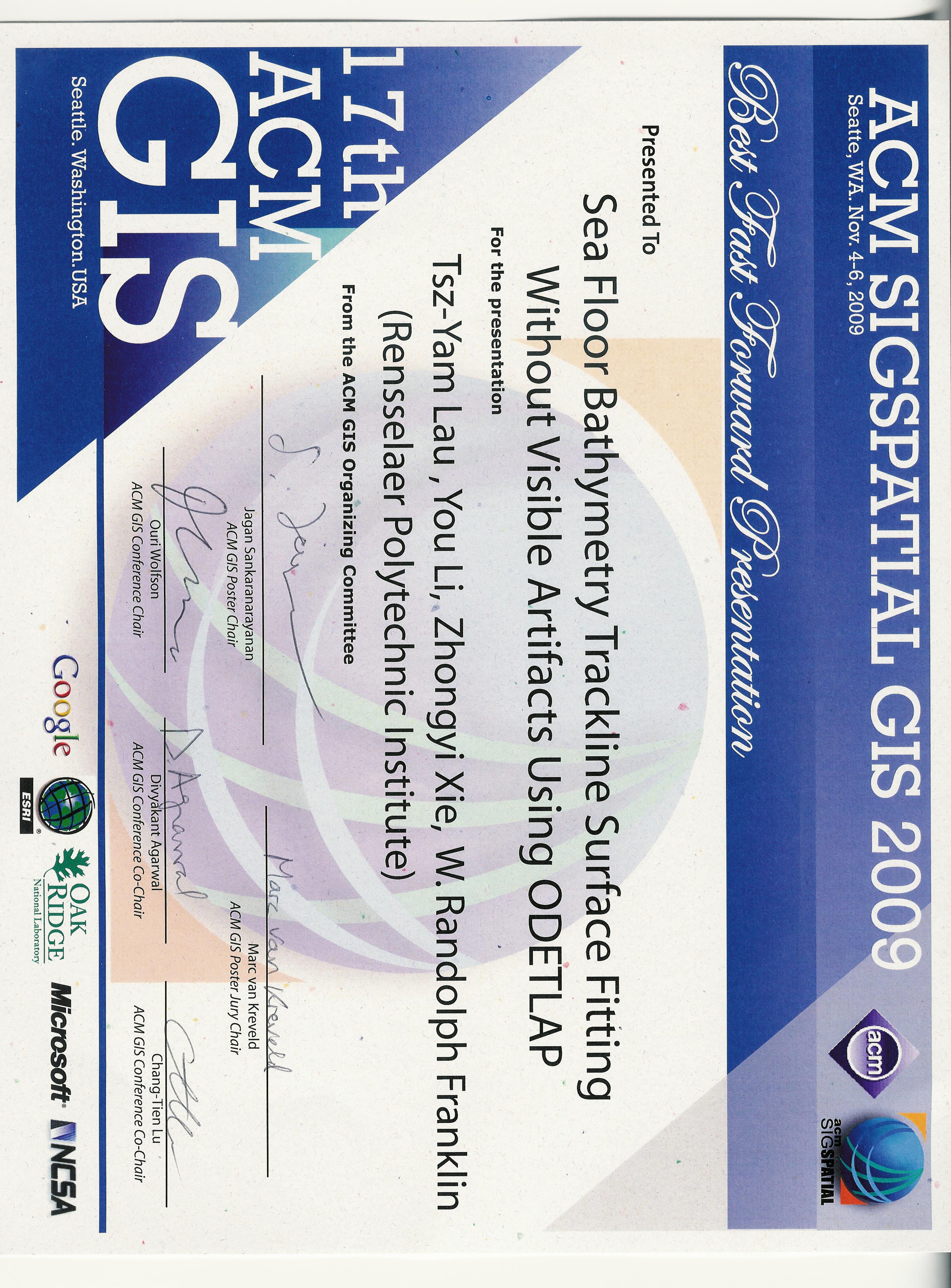
Sea floor bathymetry trackline surface fitting without visible artifacts using ODETLAP.
In 17th ACM SIGSPATIAL International Conference on Advances in Geographic Information Systems (ACM SIGSPATIAL GIS 2009). Seattle WA USA, 4–6 Nov 2009.
Winner of the best fast forward presentation award.
[details] [full text] [slides] [poster] [video] [award] [BibTeX▼] - Tsz-Yam Lau, You Li, Zhongyi Xie, and W. Randolph Franklin.
Sea floor bathymetry trackline surface fitting without visible artifacts using ODETLAP.
In 17th ACM SIGSPATIAL International Conference on Advances in Geographic Information Systems (ACM SIGSPATIAL GIS 2009). Seattle WA USA, 4–6 Nov 2009.
[details] [full text] [slides] [poster] [video] [award] [BibTeX▼] - W. Randolph Franklin.
Geostar.
March 2009.
URL: https://wrfranklin.org/pmwiki/Research/GeoStar.
[details] [BibTeX▼] - W. Randolph Franklin.
Final report – Geologically correct terrain data structures and radar siting, HM1582-05-2-0002.
March 2009.
[details] [full text] [BibTeX▼] - W. Randolph Franklin.
PNPOLY - point inclusion in polygon test.
2009.
accessed 31-Dec-2009.
URL: https://wrfranklin.org/Research/Short_Notes/pnpoly.html.
[details] [BibTeX▼] - W. Randolph Franklin.
PNPOLY - point inclusion in polygon test.
2009.
\url https://wrfranklin.org/Research/Short_Notes/pnpoly.html, accessed 31-Dec-2009.
[details] [BibTeX▼] - W. Randolph Franklin.
ECSE-6800 Advanced computer graphics and visualization.
\url https://wrfranklin.org/pmwiki/AdvancedComputerGraphicsSpring2009/ [accessed 31-Dec-2009], 2009.
[details] [BibTeX▼]
2008
- Jared Stookey, Zhongyi Xie, Barbara Cutler, W. Randolph Franklin, Daniel M. Tracy, and Marcus V.A. Andrade.
Parallel ODETLAP for terrain compression and reconstruction.
In Walid G. Aref, editor, 16th ACM SIGSPATIAL International Conference on Advances in Geographic Information Systems (ACM GIS 2008). 5–7 Nov 2008.
URL: http://acmgis08.cs.umn.edu/.
[abstract▼] [details] [full text] [slides] [poster] [BibTeX▼] - Daniel M. Tracy, W. Randolph Franklin, Barbara Cutler, Franklin T. Luk, Marcus Andrade, and Jared Stookey.
Path planning on a compressed terrain.
In Walid G. Aref and others, editors, 16th ACM SIGSPATIAL International Conference on Advances in Geographic Information Systems (ACM GIS 2008). Irvine CA, 5–7 Nov 2008.
(poster and fast forward presentation).
URL: http://acmgis08.cs.umn.edu/.
[details] [full text] [slides] [poster] [BibTeX▼] - Christopher Stuetzle, W. Randolph Franklin, Barbara Cutler, Jonathan Muckell, Marcus Andrade, Jared Stookey, Metin Inanc, and Zhongyi Xie.
Evaluating hydrology preservation of simplified terrain representations.
In Walid G. Aref and others, editors, 16th ACM SIGSPATIAL International Conference on Advances in Geographic Information Systems (ACM GIS 2008). Irvine CA, 5–7 Nov 2008.
(PhD student poster and fast forward presentation).
URL: http://acmgis08.cs.umn.edu/.
[details] [slides] [poster] [BibTeX▼] - Daniel M. Tracy, W Randolph Franklin, Barb Cutler, Franklin Luk, Marcus Andrade, and Jared Stookey.
Path planning on complex terrain.
In 18th Fall Workshop on Computational Geometry (FWCG 2008). Rensselaer Polytechnic Institute, Troy NY USA, 31 Oct – 1 Nov 2008.
(extended abstract, talk and poster).
[details] [full text] [slides] [poster] [BibTeX▼] - W. Randolph Franklin.
Operating on large geometric datasets.
In 18th Fall Workshop on Computational Geometry. Rensselaer Polytechnic Institute, Troy NY, 31 Oct – 1 Nov 2008.
(extended abstract and talk).
[details] [full text] [slides] [BibTeX▼] - Zhongyi Xie, Marcus A. Andrade, W Randolph Franklin, Barbara Cutler, Metin Inanc, Jonathan Muckell, and Daniel M. Tracy.
Progressive transmission of lossily compressed terrain.
In CLEI 2008 Conferencia Latinoamericana de Informática. Santa Fe, Argentina, 8–12 Sep 2008.
[details] [full text] [BibTeX▼] - Jonathan Muckell, Marcus Andrade, W. Randolph Franklin, Barbara Cutler, Metin Inanc, Zhongyi Xie, and Daniel M. Tracy.
Hydrology-aware constrained triangulation of terrain data.
(unpublished), Apr 2008.
[details] [full text] [BibTeX▼] - Jonathan Muckell, Marcus Andrade, W. Randolph Franklin, Barbara Cutler, Metin Inanc, Zhongyi Xie, and Daniel M. Tracy.
Evaluating hydrology preservation of simplified terrain representations.
(unpublished), Apr 2008.
[details] [full text] [BibTeX▼] - W. Randolph Franklin, Daniel M. Tracy, Marcus Andrade, Jonathan Muckell, Metin Inanc, Zhongyi Xie, and Barbara Cutler.
Slope accuracy and path planning on compressed terrain.
In Symposium on Spatial Data Handling. Montpellier FR, June 2008.
[details] [full text] [BibTeX▼]
2007
- Barbara M. Cutler and W Randolph Franklin.
Surface area of the union of many spheres.
In (submitted, rejected). 2007.
[details] [BibTeX▼] - Zhongyi Xie, Marcus A. Andrade, W. Randolph Franklin, Barbara Cutler, Metin Inanc, Daniel M. Tracy, and Jonathan Muckell.
Approximating terrain with over-determined Laplacian PDEs.
In 17th Fall Workshop on Computational Geometry. IBM TJ Watson Research Center, Hawthorne NY, 2–3 Nov 2007.
(poster session, no formal proceedings).
[details] [full text] [poster] [BibTeX▼] - Jonathan Muckell, Marcus Andrade, W. Randolph Franklin, Barbara Cutler, Metin Inanc, Zhongyi Xie, and Daniel M. Tracy.
Drainage network and watershed reconstruction on simplified terrain.
In 17th Fall Workshop on Computational Geometry. IBM TJ Watson Research Center, Hawthorne NY, 2–3 Nov 2007.
poster session, no formal proceedings.
[details] [full text] [slides] [BibTeX▼] - W Randolph Franklin, Metin Inanc, Zhongyi Xie, Daniel M. Tracy, Barbara Cutler, Marcus V A Andrade, and Franklin Luk.
Smugglers and border guards – the GeoStar project at RPI.
In 15th ACM International Symposium on Advances in Geographic Information Systems (ACM GIS 2007). Seattle, WA, USA, Nov 2007.
[abstract▼] [details] [full text] [slides] [BibTeX▼] - W. Randolph Franklin.
GeoStar April 2007 review.
\url https://wrfranklin.org/pmwiki/Research/GeoStarApril2007Review, 2007.
[Online; accessed 8-June-2007].
[details] [BibTeX▼] - Daniel M. Tracy, W. Randolph Franklin, Barbara Cutler, Marcus A Andrade, Franklin T Luk, Metin Inanc, and Zhongyi Xie.
Multiple observer siting and path planning on lossily compressed terrain.
In Proceedings of SPIE Vol. 6697 Advanced Signal Processing Algorithms, Architectures, and Implementations XVII. San Diego CA, 27 August 2007. International Society for Optical Engineering.
paper 6697-16.
[abstract▼] [details] [full text] [BibTeX▼] - Zhongyi Xie, W. Randolph Franklin, Barbara Cutler, Marcus A Andrade, Metin Inanc, and Daniel M. Tracy.
Surface compression using over-determined Laplacian approximation.
In Proceedings of SPIE Vol. 6697 Advanced Signal Processing Algorithms, Architectures, and Implementations XVII. San Diego CA, 27 August 2007. International Society for Optical Engineering.
paper 6697-15.
[abstract▼] [details] [full text] [BibTeX▼]
2006
- W. Randolph Franklin.
Smugglers' path planning on compressed terrain.
talk at UniGIS conference, May 2006.
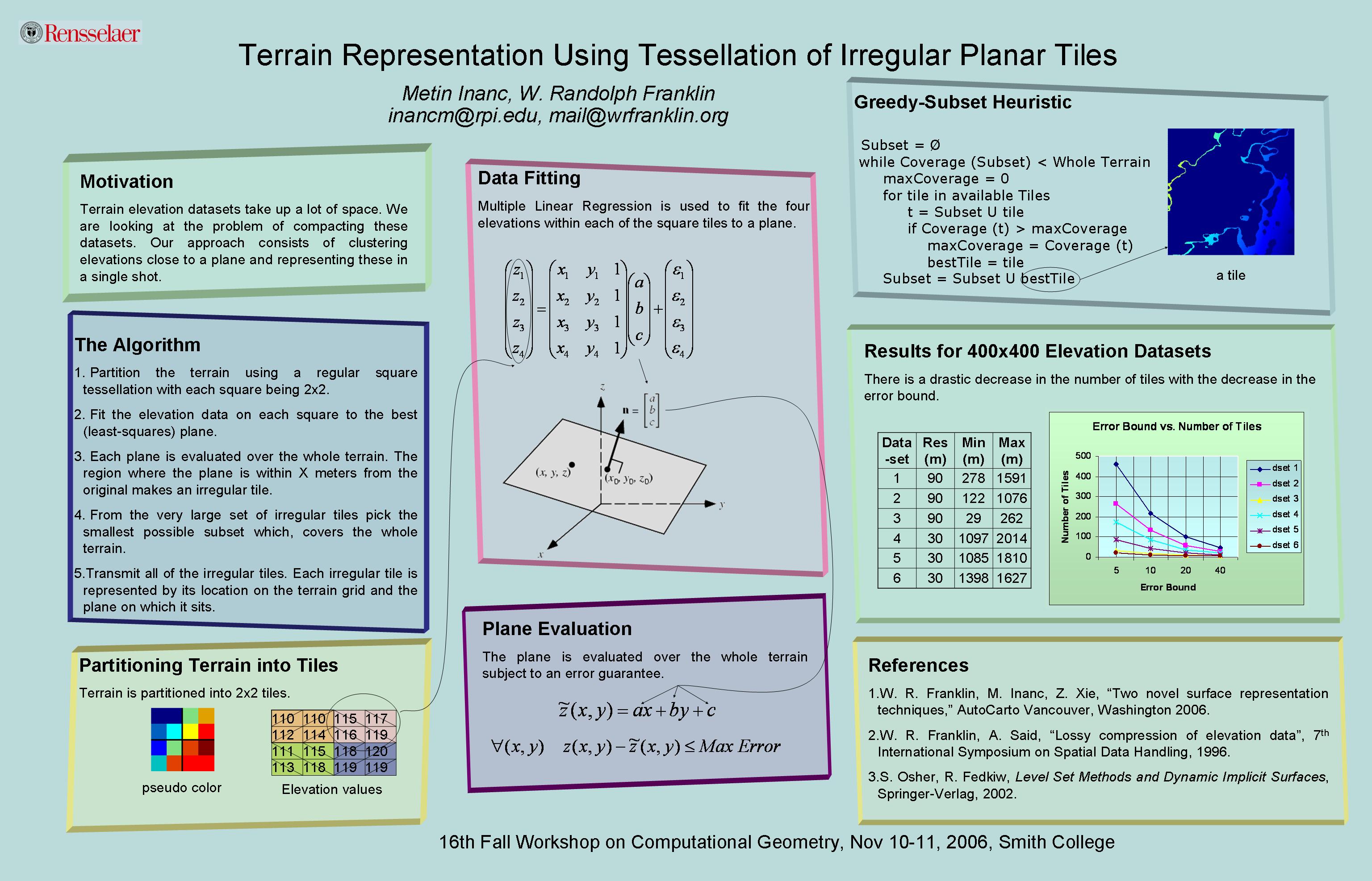
[details] [slides] [BibTeX▼] - Metin Inanc and W Randolph Franklin.
Terrain representation using tessellation of irregular planar tiles (extended abstract).
In 16th Fall Workshop on Computational Geometry. Smith College, Northampton MA, 10-11 Nov 2006.
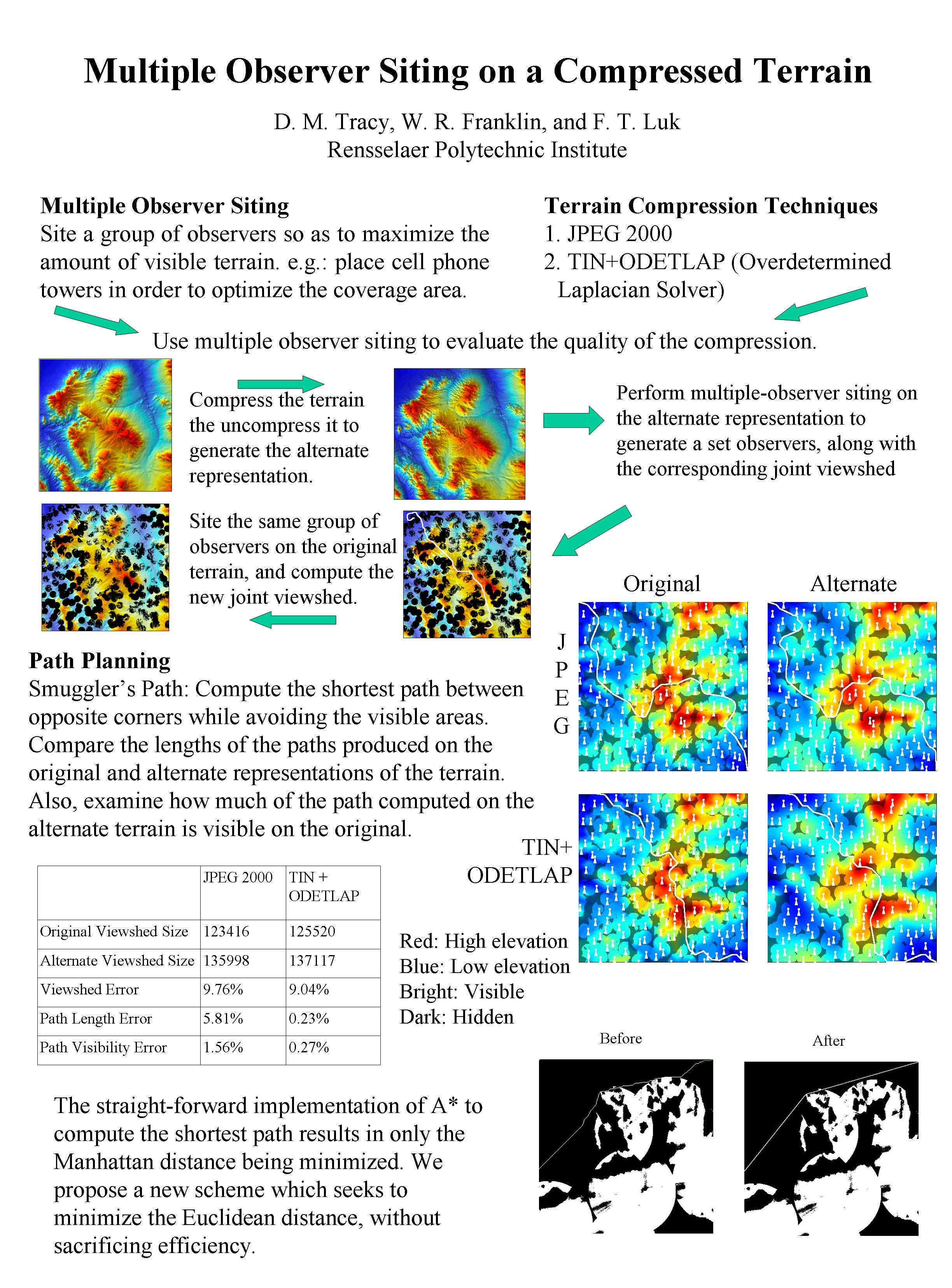
[details] [full text] [poster] [BibTeX▼] - Daniel M. Tracy, W Randolph Franklin, and Franklin Luk.
Multiple observer siting on a compressed terrain (extended abstract).
In 16th Fall Workshop on Computational Geometry. Smith College, Northampton MA, 10-11 Nov 2006.
[details] [full text] [slides] [BibTeX▼] - Caroline Westort and W. Randolph Franklin.
Alternative sculpting hypotheses for terrain data compression.
In Proceedings of SPIE Vol. 6313 Advanced Architectures, and Implementations XVI. San Diego CA, 15-16 August 2006. International Society for Optical Engineering.
6313-16, Session 4.
[abstract▼] [details] [BibTeX▼] - W. Randolph Franklin and Metin Inanc.
Compressing terrain datasets using segmentation.
In Proceedings of SPIE Vol. 6313 Advanced Architectures, and Implementations XVI. San Diego CA, 15-16 August 2006. International Society for Optical Engineering.
6313-17, Session 4.
[abstract▼] [details] [full text] [BibTeX▼] - W. Randolph Franklin and Christian Vogt.
Tradeoffs when multiple observer siting on large terrain cells.
In Andreas Riedl, Wolfgang Kainz, and Gregory Elmes, editors, Progress in Spatial Data Handling: 12th International Symposium on Spatial Data Handling, pages 845–861.
Springer, Vienna, 2006.
[details] [full text] [slides] [BibTeX▼] - W. Randolph Franklin, Metin Inanc, and Zhongyi Xie.
Two novel surface representation techniques.
In Autocarto 2006. Vancouver Washington, 25-28 June 2006. Cartography and Geographic Information Society, \url https://cartogis.org/autocarto/autocarto-2006/.
[details] [full text] [BibTeX▼] - W. Randolph Franklin and Eric Landis.
Connected components on 1000x1000x1000 datasets.
In 16th Fall Workshop on Computational Geometry. Smith College, Northampton, MA, 10-11 Nov 2006.
(extended abstract).
[details] [full text] [slides] [BibTeX▼] - Eric N. Landis, Tong Zhang, Edwin N. Nagy, George Nagy, and W. Randolph Franklin.
Cracking, damage and fracture in four dimensions.
Materials and Structures, online date: 13 July 2006.
[abstract▼] [details] [full text] [BibTeX▼] - W. Randolph Franklin.
CONNECT – find 3D connected components.
2006.
URL: https://wrfranklin.org/pmwiki/ConnectedComponents.
[details] [BibTeX▼]
2005
- Michael B. Gousie and Wm. Randolph Franklin.
Augmenting grid-based contours to improve thin plate dem generation.
Photogrammetric Engineering & Remote Sensing, 71(1):69–79, 2005.
[details] [full text] [BibTeX▼] - W. Randolph Franklin.
Nearpt3 — Nearest point query on 184M points in $E^3$ with a uniform grid.
In Proceedings of the 17th Canadian Conference on Computational Geometry (CCCG'05), 239–242. Windsor, Ontario, 10-12 August 2005.
[details] [full text] [slides] [BibTeX▼] - W. Randolph Franklin.
Nearpt3 — Nearest point query on 184M points in $E^3$ with a uniform grid.
\url https://wrfranklin.org/Research/nearpt3/, 2005.
[details] [BibTeX▼] - Wm. Randolph Franklin.
Mass properties of the union of millions of identical cubes.
In Ravi Janardan, Debashish Dutta, and Michiel Smid, editors, Geometric and Algorithmic Aspects of Computer Aided Design and Manufacturing, DIMACS Series in Discrete Mathematics and Theoretical Computer Science, volume 67, pages 329–345.
American Mathematical Society, 2005.
[details] [full text] [slides] [BibTeX▼]
2004
- W. Randolph Franklin.
Nearpt3 — Nearest point query in $E^3$ with a uniform grid (extended abstract).
In 14th Annual Fall Workshop on Computational Geometry. MIT, 20 Nov 2004.
[details] [full text] [slides] [BibTeX▼] - W. Randolph Franklin.
Analysis of mass properties of the union of millions of polyhedra.
In M. L. Lucian and M. Neamtu, editors, Geometric Modeling and Computing: Seattle 2003, pages 189–202.
Nashboro Press, Brentwood TN, 2004.
[details] [full text] [BibTeX▼] - Wm. Randolph Franklin.
Automated observer siting on terrain, showing intervisibility.
\url https://wrfranklin.org/Research/siting/, 2004.
[details] [BibTeX▼] - W. Randolph Franklin and Christian Vogt.
Efficient observer siting on large terrain cells (extended abstract).
In GIScience 2004: Third International Conference on Geographic Information Science. U Maryland College Park, 20–23 Oct 2004.
[abstract▼] [details] [full text] [slides] [BibTeX▼] - W. Randolph Franklin.
Terrain observer siting research web site.
\url https://wrfranklin.org/Research/siting/, 2004.
[details] [BibTeX▼] - W. Randolph Franklin and Christian Vogt.
Multiple observer siting on terrain with intervisibility or lo-res data.
In XXth Congress, International Society for Photogrammetry and Remote Sensing. Istanbul, 12-23 July 2004.
[abstract▼] [details] [full text] [poster] [BibTeX▼]
2003
- Michael Gousie and W. Randolph Franklin.
Constructing a DEM from grid-based data by computing intermediate contours.
In Erik Hoel and Phillippe Rigaux, editors, GIS 2003: Proceedings of the Eleventh ACM International Symposium on Advances in Geographic Information Systems, 71–77. New Orleans, 2003.
[details] [full text] [BibTeX▼] - Edwin Nagy, Tong Zhang, Wm Randolph Franklin, George Nagy, and E Landis.
3D analysis of tomographic images.
In 16th ASCE Engineering Mechanics Conference. U Washington, Seattle, 16-18 July 2003.
electronic proceedings.
[details] [full text] [BibTeX▼]
2002
- DARPA/DSO.
Geostar.
\url http://www.darpa.mil/dso/future/geo/index.htm, 2002.
[details] [BibTeX▼] - W. Randolph Franklin.
Siting observers on terrain.
In Dianne Richardson and Peter van Oosterom, editors, Advances in Spatial Data Handling: 10th International Symposium on Spatial Data Handling, 109–120. Springer-Verlag, 2002.
[abstract▼] [details] [full text] [BibTeX▼]
2001
- DARPA/DSO, W. Randolph Franklin, and Yehuda Avniel.
Geospatial terrain analysis and representations (geo*).
\url http://www.darpa.mil/dso/future/geo/index.htm, 2001.
[Online; accessed 27-Dec–2001].
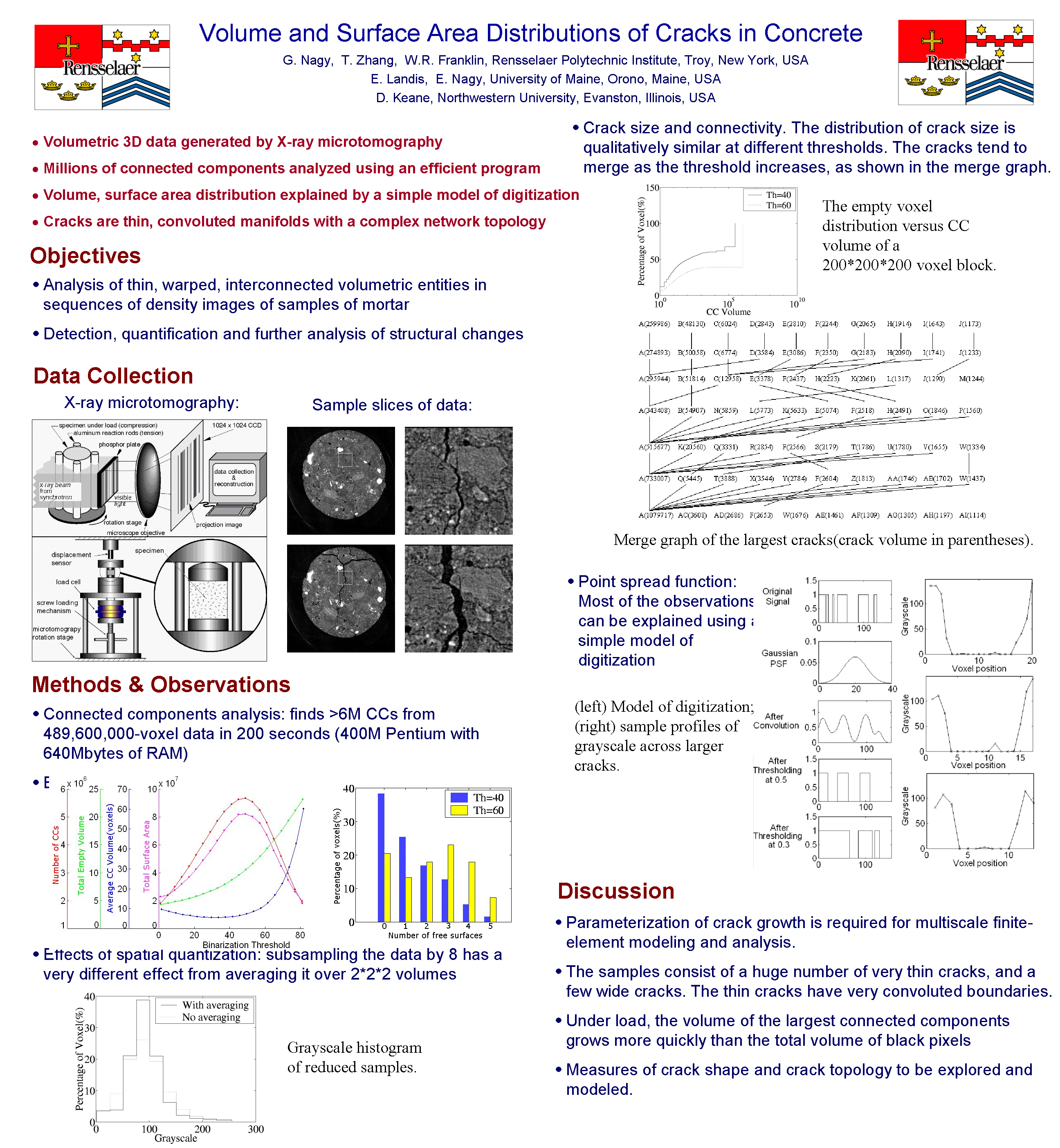
[details] [BibTeX▼] - G Nagy, T Zhang, WR Franklin, E Landis, E Nagy, and D Keane.
Volume and surface area distributions of cracks in concrete.
In C. Arcelli, L.P. Cordella, and G. Sanniti di Baja, editors, Visual Form 2001: 4th International Workshop on Visual Form IWVF4, volume 2051/2001 of Lecture Notes in Computer Science.
Springer-Verlag Heidelberg, Capri, Italy, 28-30 May 2001.
[details] [full text] [poster] [BibTeX▼] - W. Randolph Franklin, Benjamin Mann, and Douglas Cochran.
NSF 01-111 computational algorithms and representations for geometric objects (cargo).
\url http://www.nsf.gov/cgi-bin/getpub?nsf01111, May 2001.
[details] [BibTeX▼] - Hélio Pedrini, William Robson Schwartz, and W. R. Franklin.
Automatic extraction of topographic features using adaptive triangular meshes.
In 2001 International Conference on Image Processing (ICIP-2001), volume 3, 732–735. Thessaloniki, Greece, 7-10 October 2001. IEEE.
doi:https://doi.org/10.1109/ICIP.2001.958223.
[details] [BibTeX▼] - Wm. Randolph Franklin.
Triangulated irregular network computation.
2001.
accessed 8-June–2007.
URL: https://wrfranklin.org/pmwiki/Research/TriangulatedIrregularNetwork.
[details] [BibTeX▼]
2000
- Harold Moellering, Keith Clarke, Robert Cromley, Wm Randolph Franklin, Alan Saalfeld, Jon Kimerling, and Marc Armstrong.
Analytical cartography.
UCGIS Emerging Research Themes in GIScience (white paper), Dec 2000.
(UCGIS = University Consortium for Geographic Information Science).
[details] [BibTeX▼] - W. Randolph Franklin.
Approximating visibility.
In GIScience 2000. Savannah, Georgia, USA, 30 Oct 2000.
[details] [full text] [BibTeX▼] - W. Randolph Franklin.
Applications of analytical cartography.
Cartography and Geographic Information Systems, 27(3):225–237, 2000.
[details] [full text] [BibTeX▼] - W. Randolph Franklin.
Applications of geometry.
In Kenneth H Rosen, editor, Handbook of Discrete and Combinatorial Mathematics, chapter 13.8, pages 867–888.
CRC Press, 2000.
[details] [BibTeX▼]
1999
- W. Randolph Franklin and Michael Gousie.
Terrain elevation data structure operations.
In C. Peter Keller, editor, Proceedings of the 19th International Cartographic Association Conference, 1011–1020. Ottawa, August 1999.
URL: https://wrfranklin.org/wiki/Research/ica99/.
[details] [full text] [BibTeX▼]
1998
- Michael Gousie and W. Randolph Franklin.
Converting elevation contours to a grid.
In Eighth International Symposium on Spatial Data Handling, 647–656. Vancouver BC Canada, July 1998. Dept of Geography, Simon Fraser University, Burnaby, BC, Canada.
[details] [full text] [slides] [BibTeX▼]
1996
- W. Randolph Franklin and Amir Said.
Lossy compression of elevation data.
In Seventh International Symposium on Spatial Data Handling, 8B29ff. Delft, August 1996.
[details] [full text] [BibTeX▼]
1995
- W. Randolph Franklin.
Compressing elevation data.
In Fourth International Symposium on Large Spatial Databases — SSD '95. Portland, Maine, USA, 6–9 Aug 1995.
[details] [full text] [BibTeX▼] - Mohan Kankanhalli and Wm Randolph Franklin.
Area and perimeter computation of the union of a set of iso-rectangles in parallel.
J. Parallel Distrib. Comput., 27(2):107–117, June 1995.
doi:https://doi.org/10.1006/jpdc.1995.1076.
[abstract▼] [details] [full text] [BibTeX▼]
1994
- W. Randolph Franklin.
17) how do I find if a point lies within a polygon?
In J O'Rourke, editor, comp.graphics.algorithms Frequently Asked Questions (FAQ).
1994.
[details] [BibTeX▼] - W. Randolph Franklin, Jr Clark K Ray, and Shashank Mehta.
Geometric algorithms for siting of air defense missile batteries.
Technical Report, US Army Topographic Engineering Center, March 1994.
Battelle, Columbus Division Contract Number DAAL03-86-D-0001, Delivery Order Number 2756, Scientific Services Program.
[details] [BibTeX▼] - Wm. Randolph Franklin.
Overlay area calculation program.
1994.
URL: https://wrfranklin.org/wiki/Research/overlay.tgz.
[details] [BibTeX▼] - Wm Randolph Franklin and Clark Ray.
Higher isn't necessarily better: visibility algorithms and experiments.
In Thomas C. Waugh and Richard G. Healey, editors, Advances in GIS Research: Sixth International Symposium on Spatial Data Handling, 751–770. Edinburgh, 5–9 Sept 1994. The International Geographical Union's Commission on Geographical Information Systems and The Association for Geographic Information, Taylor & Francis.
[abstract▼] [details] [full text] [BibTeX▼] - Wm Randolph Franklin, Venkateshkumar Sivaswami, David Sun, Mohan Kankanhalli, and Chandrasekhar Narayanaswami.
Calculating the area of overlaid polygons without constructing the overlay.
Cartography and Geographic Information Systems, pages 81–89, April 1994.
[details] [full text] [BibTeX▼]
1993
- Wm Randolph Franklin and Mohan S. Kankanhalli.
Volumes from overlaying 3-D triangulations in parallel.
In D. Abel and B.C. Ooi, editors, Advances in Spatial Databases: Third Intl. Symp., SSD'93, volume 692 of Lecture Notes in Computer Science, pages 477–489.
Springer-Verlag, June 1993.
[details] [full text] [BibTeX▼] - UCGIA Steering Committee.
On the possible role(s) of a “university consortium for geographic information and analysis” (UCGIA).
In Proceedings, American Congress on Surveying and Mapping / American Society for Photogrammetry and Remote Sensing '93. New Orleans, 1993.
[details] [BibTeX▼]
1992
-
Renamed local topo report.
1992.
[details] [BibTeX▼] - Chandrasekhar Narayanaswami and Wm Randolph Franklin.
Boolean combinations of polygons in parallel.
In Proceedings of the 1992 International Conference on Parallel Processing, volume. 17–21 Aug 1992.
[details] [full text] [BibTeX▼] - Wm Randolph Franklin.
Map overlay area animation and parallel simulation.
In David H. Douglas, editor, Proceedings, SORSA'92 Symposium and Workshop, 200–203. July 28–August 2 1992.
[details] [full text] [BibTeX▼] - Wm Randolph Franklin.
Tutorial on curve fitting for GIS.
In David H. Douglas, editor, Proceedings, SORSA'92 Symposium and Workshop. July 28–August 2 1992.
[details] [full text] [BibTeX▼] - Chandrasekhar Narayanaswami and Wm Randolph Franklin.
Edge intersection on the Hypercube computer.
Information Processing Letters, 41(5):257–262, 3 April 1992.
[details] [full text] [BibTeX▼] - WR Franklin.
Local topological properties of polyhedra.
(unpublished talk), Sept 1992.
URL: https://wrfranklin.org/wiki/Research/unpub/localtopo.pdf.
[abstract▼] [details] [BibTeX▼]
1991
- Chandrasekhar Narayanaswami and Wm Randolph Franklin.
Determination of mass properties of polygonal CSG objects in parallel.
In Joshua Turner, editor, Proc. Symposium on Solid Modeling Foundations and CAD/CAM Applications, pages 279–288.
ACM/SIGGRAPH, 5–7 June 1991.
[details] [full text] [BibTeX▼] - Wm Randolph Franklin.
Computer systems and low level data structures for GIS.
In David Maguire, Mike Goodchild, and David Rhind, editors, Geographical Information Systems, Principles and Applications, volume 1, pages 215–225.
Longman Scientific and Technical, London UK, 1991.
[details] [full text] [BibTeX▼] - C. Narayanaswami and Wm Randolph Franklin.
Determination of mass properties of polygonal CSG objects in parallel.
Internat. J. Comput. Geom. Appl., 1(4):381–403, 1991.
[details] [full text] [BibTeX▼] - Varol Akman, A. Arslan, W. Randolph Franklin, and P. J. W. ten Hagen.
Implementing a topological picturebook.
In Proc. 13th IMACS World Congress on Computation and Applied Maths. Dublin, 1991.
[details] [BibTeX▼] - W. Randolph Franklin, Rahul Bansal, and Elissa Gilbert.
Sensitivity analysis of expert systems.
In Uma G. Gupta, editor, Validating and Verifying Knowledge-Based Systems, pages 347–355.
IEEE Computer Society Press, 1991.
[details] [full text] [BibTeX▼]
1990
- Varol Akman, D. Ede, W. Randolph Franklin, and P. J. W. ten Hagen.
Mental models of force and motion.
In Okyay Kaynak, editor, Proc. IEEE International Workshop on Intelligent Motion Control, volume 1, 153–158. Bogazici University, Istanbul, 20-22 August 1990. IEEE Press. Catalog No. 90TH0272-5.
[details] [BibTeX▼] - Wm Randolph Franklin.
Calculating map overlay polygon' areas without explicitly calculating the polygons — implementation.
In 4th International Symposium on Spatial Data Handling, 151–160. Zürich, 23-27 July 1990.
[details] [full text] [BibTeX▼] - Wm Randolph Franklin, Narayanaswami Chandrasekhar, Mohan Kankanhalli, Varol Akman, and Peter YF Wu.
Efficient geometric operations for CAD.
In Michael J. Wozny, Joshua U. Turner, and K. Preiss, editors, Geometric Modeling for Product Engineering, pages 485–498.
Elsevier Science Publishers B.V. (North-Holland), 1990.
[details] [full text] [BibTeX▼] - Wm Randolph Franklin and Mohan Kankanhalli.
Parallel object-space hidden surface removal.
In Proceedings of SIGGRAPH'90, volume 24, 87–94. August 1990.
[details] [full text] [BibTeX▼] - Wm Randolph Franklin and Venkatesh Sivaswami.
OVERPROP — calculating areas of map overlay polygons without calculating the overlay.
In Canadian National Conference on Geographic Information Systems: Challenge for the 1990's, 1646–1654. Ottawa, 5-8 Mar 1990. Canadian Institute of Surveying and Mapping.
[details] [full text] [BibTeX▼] - Peter Y.F. Wu and W. Randolph Franklin.
A logic programming approach to cartographic map overlay.
Journal of Computational Intelligence, 6(2):61–70, May 1990.
doi:https://doi.org/10.1111/j.1467-8640.1990.tb00290.x.
[details] [full text] [BibTeX▼]
1989
- Wm. Randolph Franklin.
Review of Art Gallery Theorems and Algorithms by Joseph O'Rourke.
SIAM Review, 31(2):342–343, June 1989.
[details] [full text] [BibTeX▼] - Varol Akman and Wm Randolph Franklin.
Representing objects as rays, or how to pile up an octree?
Computers and Graphics, 13(3):373–379, 1989.
[details] [full text] [BibTeX▼] - W. Randolph Franklin, Narayanaswami Chandrasekhar, and Mohan Kankanhalli.
Parallel algorithms for geometric computing.
In Final Program, SIAM Conference on Geometric Design, A17. 6–10 Nov 1989.
(abstract only).
[details] [BibTeX▼] - Varol Akman and Wm Randolph Franklin.
Ray representation for k-d trees.
Pattern Recognition Letters, pages 315–320, November 1989.
[details] [full text] [BibTeX▼] - Wm Randolph Franklin, Mohan Kankanhalli, Chandrasekhar Narayanaswami, and Varol Akman.
Efficient intersection calculations in large databases.
In International Cartographic Association 14th World Conference, A–62 – A–63. Budapest, August 1989.
[details] [full text] [BibTeX▼] - Wm Randolph Franklin, Mohan Kankanhalli, and Chandrasekhar Narayanaswami.
Efficient primitive geometric operations on large databases.
In Proceedings National Conference Challenge for the 1990s GIS Geographic Information Systems, 1247–1256. Ottawa, 27 February - 3 Mar 1989. Canadian Institute of Surveying and Mapping.
[details] [full text] [BibTeX▼] - Varol Akman, Wm Randolph Franklin, Mohan Kankanhalli, and Chandrasekhar Narayanaswami.
Geometric computing and the uniform grid data technique.
Computer Aided Design, 21(7):410–420, 1989.
[details] [full text] [BibTeX▼] - Wm Randolph Franklin, Chandrasekhar Narayanaswami, Mohan Kankanhalli, David Sun, Meng-Chu Zhou, and Peter YF Wu.
Uniform grids: a technique for intersection detection on serial and parallel machines.
In Proceedings of Auto Carto 9: Ninth International Symposium on Computer-Assisted Cartography, 100–109. Baltimore, Maryland, 2-7 April 1989.
[details] [full text] [BibTeX▼] - Varol Akman, W. Randolph Franklin, and B. Veth.
Design systems with common sense.
In PJW ten Hagen and P. Veerkamp, editors, Proceedings of the Third Eurographics Workshop on Intelligent CAD Systems: Practical Experience and Evaluation, 317–322. Texel, the Netherlands, 3-7 Apr 1989. Springer–Verlag.
[details] [BibTeX▼]
1988
- Wm. Randolph Franklin.
Review of Computational Geometry: An Introduction by Franco P. Preparata and Michael Ian Shamos.
SIAM Review, 30(4):669–670, December 1988.
[details] [full text] [BibTeX▼] - W. Randolph Franklin, Rahul Bansal, Elissa Gilbert, and Gautam Shroff.
Debugging and tracing expert systems.
In Benn R. Konsynski, editor, Proceeding of the 21st International Hawaii International Conference on System Sciences, volume III, 159–167. Kona, Hawaii, January 1988.
[details] [full text] [BibTeX▼] - Wm Randolph Franklin.
A linear time exact hidden surface algorithm.
In Kenneth I. Joy and others, editors, Tutorial: Computer Graphics: Image Synthesis, pages 218–224.
1988.
[details] [BibTeX▼] - Wm Randolph Franklin and Varol Akman.
Adaptive grid for polyhedral visibility in object space, an implementation.
Computer Journal, 31(1):56–60, February 1988.
[details] [full text] [BibTeX▼] - Wm Randolph Franklin, Narayanaswami Chandrasekhar., Mohan Kankanhalli, Manoj Seshan, and Varol Akman.
Efficiency of uniform grids for intersection detection on serial and parallel machines.
In Nadia Magnenat-Thalmann and D. Thalmann, editors, New Trends in Computer Graphics (Proc. Computer Graphics International'88), pages 288–297.
Springer-Verlag, 1988.
[details] [full text] [BibTeX▼] - WR Franklin, N. Chandrasekhar, M. Kankanhalli, and V. Akman.
Fast intersection detection on serial and parallel machines using the uniform grid technique.
1988.
[details] [full text] [BibTeX▼]
1987
- Wm Randolph Franklin.
Polygon properties calculated from the vertex neighborhoods.
In Proc. 3rd Annu. ACM Sympos. Comput. Geom., 110–118. 1987.
[details] [full text] [BibTeX▼] - Wm Randolph Franklin and V. Akman.
A workbench to compute unobstructed shortest paths in three-space.
In Proc. 1st Internat. Conf. Indust. Applied Math., 1–38. Paris, France, 1987.
[details] [full text] [BibTeX▼] - Wm Randolph Franklin and Varol Akman.
A simple and efficient haloed line algorithm for hidden line elimination.
Computer Graphics Forum, 6(2):103–109, May 1987.
[details] [full text] [BibTeX▼] - Wm Randolph Franklin and Peter YF Wu.
A polygon overlay system in prolog.
In Autocarto 8: Proceedings of the Eighth International Symposium on Computer-Assisted Cartography, 97–106. Baltimore, Maryland, 29 Mar – 3 April 1987.
[details] [full text] [BibTeX▼]
1986
- Varol Akman and W. Randolph Franklin.
Locus techniques for shortest path problems in robotics.
In IFAC Symposium on Robot Control (SYSROCO'85).
Barcelona, 1986.
[details] [full text] [BibTeX▼] - Varol Akman and Wm Randolph Franklin.
On the question `is $\sum _1^n \sqrt a_i\le L ?$'.
EATCS Bulletin, pages 16–20, February 1986.
[details] [full text] [BibTeX▼] - Wm Randolph Franklin, Margaret Nichols, Sumitro Samaddar, and Peter YF Wu.
Experiences with using prolog for geometry.
In Proceedings of Graphics Interface'86, Vision Interface'86, 26–31. Vancouver, BC, 26–30 May 1986.
[details] [BibTeX▼] - Wm Randolph Franklin, Peter Y.F. Wu, Sumitro Samaddar, and Margaret Nichols.
Geometry in prolog.
In Tosiyasu Kunii, editor, Advanced Computer Graphics, Proceedings of Computer Graphics Tokyo 86, 71–78. April 1986.
[details] [full text] [BibTeX▼] - Wm Randolph Franklin and Varol Akman.
Reconstructing visible regions from visible segments.
BIT, 26:430–441, 1986.
[details] [full text] [BibTeX▼] - Wm Randolph Franklin, Peter Y.F. Wu, Sumitro Samaddar, and Margaret Nichols.
Prolog and geometry projects.
IEEE Computer Graphics and Applications, pages 46–55, November 1986.
[details] [full text] [BibTeX▼] - Wm Randolph Franklin.
Problems with raster graphics algorithms.
In L.R.A. Kessener, F.J. Peters, and M.L.P. van Lierop, editors, Data Structures for Raster Graphics, proceedings of a Workshop held at Steensel, The Netherlands, June 24–28, 1985, pages 1–8.
Springer-Verlag EurographicSeminars, 1986.
[details] [full text] [BibTeX▼]
1985
- Wm. Randolph Franklin and Peter Y. F. Wu.
Convex hull and polygon intersection in Prolog.
(presented at SIAM GM&R), 18 Jul 1985.
[details] [full text] [BibTeX▼] - Wm Randolph Franklin.
Computational geometry in prolog.
In Proceedings of the NATO Advanced Study Institute on Fundamental Algorithms for Computer Graphics, volume 17 of NATO ASI Series F, pages 737–749.
Springer-Verlag, Ilkley, Yorkshire, England, 30 March – 12 April 1985.
[details] [full text] [BibTeX▼] - Wm Randolph Franklin and Varol Akman.
Shortest paths in 3-space, Voronoi diagrams with barriers, and related complexity and algebraic issues.
In Proceedings of the NATO Advanced Study Institute on Fundamental Algorithms for Computer Graphics, volume 17 of NATO ASI Series F, pages 895–917.
Springer-Verlag, Ilkley, Yorkshire, England, 30 March – 12 April 1985.
[details] [full text] [BibTeX▼] - Wm Randolph Franklin and Varol Akman.
Shortest paths in 3-space, Voronoi diagrams with barriers, and related complexity and algebraic issues.
In L. Basañez, Gabriel A. Ferraté, and George N. Saridis, editors, Robot Control (SYROCO '85): Proceedings of the 1st IFAC Symposium, volume 1, pages 271–275.
International Federation of Automatic Control, Barcelona, Spain, 6–8 November 1985.
[details] [BibTeX▼] - Wm Randolph Franklin and Varol Akman.
Building an octree from a set of parallelepipeds.
IEEE Computer Graphics and Applications, 5(10):58–64, October 1985.
[details] [full text] [BibTeX▼] - Wm Randolph Franklin and Varol Akman.
Octree data structures and creation by stacking.
In Nadia Magenat-Thalmann, editor, Computer Generated Images, State of the Art.
Springer-Verlag, 1985.
[details] [full text] [BibTeX▼] - Wm Randolph Franklin, Varol Akman, and Colin Verrilli.
Voronoi diagrams with barriers and on polyhedra for minimal path planning.
Visual Comput., 1(2):133–150, October 1985.
[details] [full text] [BibTeX▼] - Wm Randolph Franklin and Varol Akman.
Building an octree from a set of parallelepipeds.
In Graphics Interface. 1985.
[details] [full text] [BibTeX▼] - Varol Akman and W. Randolph Franklin.
Partitioning the space to calculate shortest paths to any goal around polyhedral obstacles.
In Proceedings of ROBEXS'85, the First Annual Workshop on Robotics and Expert Systems. NASA/Johnson Space Center, 27–28 June 1985.
[details] [full text] [BibTeX▼]
1984
- Wm Randolph Franklin.
Cartographic errors symptomatic of underlying algebra problems.
In Proc. International Symposium on Spatial Data Handling, volume 1, 190–208. Zürich, 20–24 August 1984.
[details] [full text] [BibTeX▼] - Wm Randolph Franklin.
Adaptive grids for geometric operations.
Cartographica, 21(2–3):161–167, Summer – Autumn 1984.
monograph 32–33.
[details] [full text] [BibTeX▼] - Wm Randolph Franklin and Varol Akman.
Shortest paths between source and goal points located on/around a convex polyhedron.
In 22nd Annual Allerton Conference on Communication, Control, and Computing. Urbana, Illinois, USA, 3–5 October 1984.
[details] [full text] [BibTeX▼] - W. Randolph Franklin.
A simpler iterative solution to the Towers of Hanoi problem.
SIGPLAN Notices, 19(8):87–88, August 1984.
[details] [full text] [BibTeX▼]
1983
- Wm Randolph Franklin.
Rays — new representation for polygons and polyhedra.
Computer Graphics and Image Processing, 22:327–338, 1983.
[details] [full text] [BibTeX▼] - Wm Randolph Franklin.
Efficient rotation of an object.
IEEE Trans. Comput., C-32(11):1064–1067, November 1983.
[details] [full text] [BibTeX▼] - Wm Randolph Franklin.
A simplified map overlay algorithm.
In Harvard Computer Graphics Conference. Cambridge, Mass, USA, 31 July – 4 August 1983.
[details] [full text] [BibTeX▼] - Wm Randolph Franklin.
Adaptive grids for geometric operations.
In Barry S Wellar, editor, Proc. Sixth International Symposium on Automated Cartography (Auto-Carto Six), Volume II: Automated Cartography: international perspectives on achievements and challenges, 230–239. Ottawa, 1983.
[details] [BibTeX▼] - W. Randolph Franklin.
Software aspects of business graphics.
Computers and Graphics, 1983.
(invited paper).
[details] [full text] [BibTeX▼]
1982
- W. Randolph Franklin.
Software engineering reasons for vlsi design methodology.
In IEEE Computer Society Workshop Report: VLSI and Software Engineering Workshop, pages 86–89.
Port Chester, NY, USA, 4–6 October 1982.
[details] [full text] [BibTeX▼] - W. Randolph Franklin.
Program translates statistics into 3-D color map of europe.
IEEE Computer and Applications, 2(5):front cover and p. 4, July 1982.
(invited).
[details] [BibTeX▼] - W. Randolph Franklin.
On an improved algorithm for decentralized extrema finding.
Comm. ACM, 25(5):336–337, May 1982.
[details] [full text] [BibTeX▼] - G. Wazzan, W. Randolph Franklin, W. R. Spillers, A. Greenwood, T. F. Gantry, and H. Chu.
Simulation of buried power transmission systems: some computer graphics options.
Computers and Graphics, 6(1):7–14, 1982.
[details] [full text] [BibTeX▼] - Wm Randolph Franklin.
Efficient polyhedron intersection and union.
In Proc. Graphics Interface, 73–80. Toronto, 1982.
[details] [full text] [BibTeX▼]
1981
- Wm Randolph Franklin.
An exact hidden sphere algorithm that operates in linear time.
Comput. Graph. Image Process., 15:364–379, 1981.
[details] [full text] [BibTeX▼] - Wm Randolph Franklin.
3-D geometric databases using hierarchies of inscribing boxes.
In Proceedings of the 7th Canadian Man-Computer Conference, 173–180. Waterloo, Ontario, Canada, 10–12 June 1981.
[details] [full text] [BibTeX▼] - W. Randolph Franklin and Alan H. Barr.
Faster calculation of superquadric shapes.
IEEE Computer Graphics and Applications, 1(3):41–47, July 1981.
[details] [full text] [BibTeX▼]
1980
- Wm Randolph Franklin.
A linear time exact hidden surface algorithm.
Comput. Graph., 14(3):117–123, 1980.
[details] [full text] [BibTeX▼]
1979
- Wm Randolph Franklin.
Evaluation of algorithms to display vector plots on raster devices.
Computer Graphics and Image Processing, 11(4):377–397, December 1979.
[details] [BibTeX▼] - W. Randolph Franklin.
Padded lists—set operations in $O(log log N)$ time.
Information Processing Letters, 9(4):161–166, November 1979.
[details] [full text] [BibTeX▼] - W. Randolph Franklin.
Prism — a prism plotting program.
In Allan H. Schmidt, editor, Mapping Software and Cartographic Data Bases, Harvard Library of Computer Mapping, 1979 collection, pages 75–79.
1979.
[details] [BibTeX▼]
1978
- Wm Randolph Franklin and Harry R. Lewis.
3-D graphic display of discrete spatial data by prism maps.
In Proc. SIGGRAPH'78, volume 12(3), 70–75. August 1978.
[details] [full text] [BibTeX▼] - Wm Randolph Franklin.
Combinatorics of hidden surface algorithms.
Technical Report, Center for Research in Computing Technology, Harvard Univ., Cambridge, MA, June 1978.
[details] [full text] [BibTeX▼] - William G. Nisen and W. Randolph Franklin.
The maturation of computer graphics.
ICP Interface Manufacturing and Engineering, 3(4):5–11, 1978.
[details] [full text] [BibTeX▼]
1973
- Wm. Randolph Franklin.
Triangulated irregular network program.
1973.
accessed 30 Oct 2008.
URL: http://wrfranklin.org/wiki/Research/tin73.tgz.
[details] [BibTeX▼]