Terrain visibility, viewshed, Multiple observer siting
2020
- W. Randolph Franklin, Salles Viana Gomes de Magalhães, and Wenli Li.
Siting thousands of radio transmitter towers on terrains with billions of points.
2020.
arXiv 2006.16783.
arXiv:2006.16783.
[abstract▼] [details] [full text] [BibTeX▼]
2017
- Wenli Li and W. Randolph Franklin.
GPU–accelerated multiple observer siting.
Photogrammetric Engineering & Remote Sensing, 83(6):439–446, June 2017.
doi:https://doi.org/10.14358/PERS.83.6.439.
[abstract▼] [details] [full text] [BibTeX▼]
2016
- Wenli Li, W. Randolph Franklin, and Salles V. G. de Magalhães.
Computing approximate horizons on a GPU.
In 26th Fall Workshop on Computational Geometry. CUNY Graduate Center, New York, USA, 27-28 Oct 2016.
(extended abstract).
[abstract▼] [details] [full text] [slides] [BibTeX▼] - Chaulio R. Ferreira, Marcus V. A. Andrade, Salles V. G. de Magalhães, and W. Randolph Franklin.
An efficient external memory algorithm for terrain viewshed computation.
ACM Trans. on Spatial Algorithms and Systems, 2016.
doi:https://doi.org/10.1145/2903206.
[abstract▼] [details] [full text] [BibTeX▼] - Max J Egenhofer, Keith C Clarke, Song Gao, Teriitutea Quesnot, W. Randolph Franklin, May Yuan, and David Coleman.
Contributions of GIScience over the past twenty years.
In Harlan Onsrud and Werner Kuhn, editors, Advancing Geographic Information Science: The Past and Next Twenty Years, chapter 1, pages 9–34.
GSDI association press, 2016.
[abstract▼] [details] [full text] [BibTeX▼] - Wenli Li.
GPU-accelerated terrain processing.
PhD thesis, Rensselaer Polytechnic Institute, 2016.
[abstract▼] [details] [full text] [BibTeX▼]
2015
- Maurício Gouvêa Gruppi, Salles V. G. de Magalhães, Marcus V. A. Andrade, W. Randolph Franklin, and Wenli Li.
Using rational numbers and parallel computing to efficiently avoid round-off errors on map simplification.
In Geoinfo 2015, XVI Brazilian Symposium on GeoInformatics. Campos do Jordão, SP, Brazil, 29 Nov – 2 Dec 2015.
[abstract▼] [details] [full text] [slides] [BibTeX▼]
2014
- Wenli Li, W. Randolph Franklin, Daniel N. Benedetti, and Salles V. G. de Magalhães.
Parallel multiple observer siting on terrain.
In 22nd ACM SIGSPATIAL International Conference on Advances in Geographic Information Systems (ACM SIGSPATIAL 2014). Dallas, Texas, USA, 4–7 Nov 2014.
[abstract▼] [details] [full text] [poster] [BibTeX▼] - Guilherme Pena, Salles de Magalhães, Marcus Andrade, Randolph Franklin, Chaulio Ferreira, Wenli Li, and Daniel Benedetti.
An efficient GPU multiple-observer siting method based on sparse-matrix multiplication.
In 3rd ACM SIGSPATIAL International Workshop on Analytics for Big Geospatial Data (BigSpatial) 2014. Dallas TX USA, 4 Nov 2014.
[abstract▼] [details] [full text] [slides] [BibTeX▼] - Chaulio R. Ferreira, Marcus V. A. Andrade, Salles V. G. de Magalhães, W. R. Franklin, and Guilherme C. Pena.
A parallel algorithm for viewshed computation on grid terrains.
Journal of information and data management, 2014.
invited.
[abstract▼] [details] [full text] [BibTeX▼] - Guilherme C. Pena, Marcus V.A. Andrade, Salles V.G. de Magalhães, W. R. Franklin, and Chaulio R. Ferreira.
An improved parallel algorithm using GPU for siting observers on terrain.
In 16th International Conference on Enterprise Information Systems (ICEIS 2014), 367–375. Lisbon, 27–30 April 2014.
doi:https://doi.org/10.5220/0004884303670375.
[abstract▼] [details] [full text] [slides] [BibTeX▼]
2013
- Chaulio R. Ferreira, Marcus V. A. Andrade, Salles V. G. de Magalhães, W. R. Franklin, and Guilherme C. Pena.
A parallel sweep line algorithm for visibility computation.
In Geoinfo 2013, XIV Brazilian Symposium on GeoInformatics. Campos do Jordão, SP, Brazil, 24–27 Nov 2013.
Winner of best paper award, \url http://www.geoinfo.info/geoinfo2013/index.php.
[abstract▼] [details] [full text] [BibTeX▼]
2012
- Chaulio R. Ferreira, Salles V. G. de Magalhães, Marcus V. A. Andrade, W. Randolph Franklin, and André M. Pompermayer.
More efficient terrain viewshed computation on massive datasets using external memory.
In 20th ACM SIGSPATIAL International Conference on Advances in Geographic Information Systems (ACM SIGSPATIAL GIS 2012). Redondo Beach, CA, 6–9 Nov 2012.
[abstract▼] [details] [full text] [poster] [BibTeX▼]
2011
- Salles V. G. de Magalhães, Marcus V. A. Andrade, and W. Randolph Franklin.
Multiple observer siting in huge terrains stored in external memory.
International Journal of Computer Information Systems and Industrial Management (IJCISIM), 2011.
[abstract▼] [details] [full text] [BibTeX▼]
2010
- Marcus V. A. Andrade, Salles V. G. de Magalhães, Mirella A. de Magalhães, W. Randolph Franklin, and Barbara M. Cutler.
Efficient viewshed computation on terrain in external memory.
Geoinformatica, 2010.
(online 26 Nov 2009).
URL: http://www.springerlink.com/content/p1783648185g1252/, doi:https://doi.org/10.1007/s10707-009-0100-9.
[abstract▼] [details] [full text] [BibTeX▼]
2007
- W Randolph Franklin, Metin Inanc, Zhongyi Xie, Daniel M. Tracy, Barbara Cutler, Marcus V A Andrade, and Franklin Luk.
Smugglers and border guards – the GeoStar project at RPI.
In 15th ACM International Symposium on Advances in Geographic Information Systems (ACM GIS 2007). Seattle, WA, USA, Nov 2007.
[abstract▼] [details] [full text] [slides] [BibTeX▼] - Daniel M. Tracy, W. Randolph Franklin, Barbara Cutler, Marcus A Andrade, Franklin T Luk, Metin Inanc, and Zhongyi Xie.
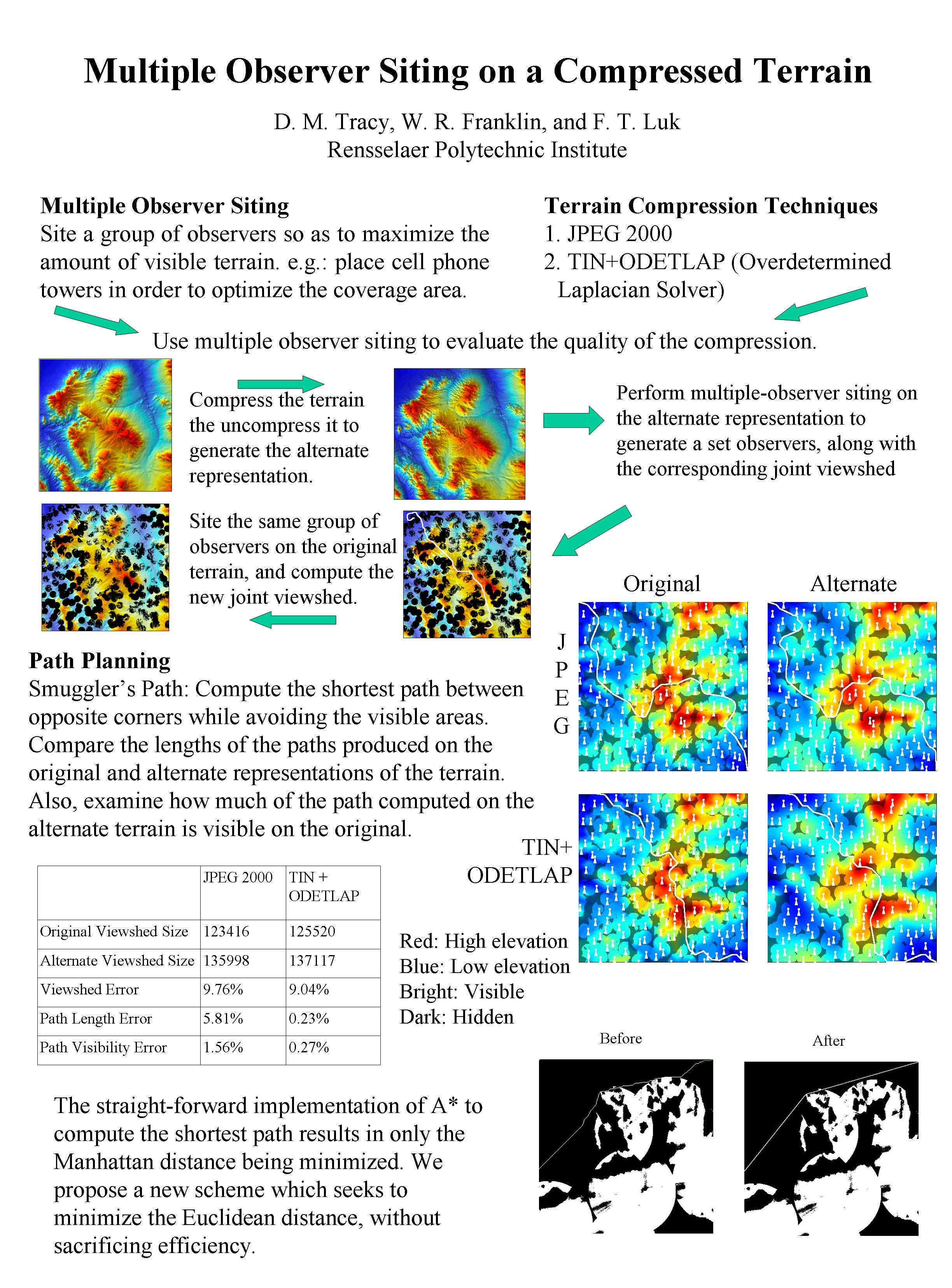
Multiple observer siting and path planning on lossily compressed terrain.
In Proceedings of SPIE Vol. 6697 Advanced Signal Processing Algorithms, Architectures, and Implementations XVII. San Diego CA, 27 August 2007. International Society for Optical Engineering.
paper 6697-16.
[abstract▼] [details] [full text] [BibTeX▼]
2006
- Daniel M. Tracy, W Randolph Franklin, and Franklin Luk.
Multiple observer siting on a compressed terrain (extended abstract).
In 16th Fall Workshop on Computational Geometry. Smith College, Northampton MA, 10-11 Nov 2006.
[details] [full text] [slides] [BibTeX▼] - W. Randolph Franklin and Christian Vogt.
Tradeoffs when multiple observer siting on large terrain cells.
In Andreas Riedl, Wolfgang Kainz, and Gregory Elmes, editors, Progress in Spatial Data Handling: 12th International Symposium on Spatial Data Handling, pages 845–861.
Springer, Vienna, 2006.
[details] [full text] [slides] [BibTeX▼]
2004
- W. Randolph Franklin and Christian Vogt.
Efficient observer siting on large terrain cells (extended abstract).
In GIScience 2004: Third International Conference on Geographic Information Science. U Maryland College Park, 20–23 Oct 2004.
[abstract▼] [details] [full text] [slides] [BibTeX▼] - W. Randolph Franklin.
Terrain observer siting research web site.
\url https://wrfranklin.org/Research/siting/, 2004.
[details] [BibTeX▼] - W. Randolph Franklin and Christian Vogt.
Multiple observer siting on terrain with intervisibility or lo-res data.
In XXth Congress, International Society for Photogrammetry and Remote Sensing. Istanbul, 12-23 July 2004.
[abstract▼] [details] [full text] [poster] [BibTeX▼]
2002
- W. Randolph Franklin.
Siting observers on terrain.
In Dianne Richardson and Peter van Oosterom, editors, Advances in Spatial Data Handling: 10th International Symposium on Spatial Data Handling, 109–120. Springer-Verlag, 2002.
[abstract▼] [details] [full text] [BibTeX▼]
2000
- W. Randolph Franklin.
Approximating visibility.
In GIScience 2000. Savannah, Georgia, USA, 30 Oct 2000.
[details] [full text] [BibTeX▼]
1994
- Wm Randolph Franklin and Clark Ray.
Higher isn't necessarily better: visibility algorithms and experiments.
In Thomas C. Waugh and Richard G. Healey, editors, Advances in GIS Research: Sixth International Symposium on Spatial Data Handling, 751–770. Edinburgh, 5–9 Sept 1994. The International Geographical Union's Commission on Geographical Information Systems and The Association for Geographic Information, Taylor & Francis.
[abstract▼] [details] [full text] [BibTeX▼]
Contact: WRF