Terrain representation theory, including interpolating contours
See also ODETLAP
2012
- Christopher Stuetzle and W. Randolph Franklin.
Representation of terrain data by drilling process.
In 2012 AutoCarto International Symposium on Automated Cartography. Columbus OH, 16–18 Sep 2012.
abstract.
[details] [full text] [slides] [BibTeX▼] - Christopher Stuetzle and W. Randolph Franklin.
Representing terrain with mathematical operators.
In 15th International Symposium on Spatial Data Handling. Bonn, Germany, 22–24 Aug 2012.
[details] [full text] [slides] [video] [BibTeX▼]
2011
- Christopher Stuetzle, Barbara Cutler, Zhongxian Chen, W. Randolph Franklin, Mehrad Kamalzare, and Thomas Zimmie.
Ph.d. showcase: measuring terrain distances through extracted channel networks.
In 19th ACM SIGSPATIAL International Conference on Advances in Geographic Information Systems (ACM SIGSPATIAL GIS 2011). Chicago USA, 1–4 Nov 2011.
[details] [full text] [poster] [BibTeX▼]
2010
- W. Randolph Franklin.
Towards a mathematics of terrain.
In 20th Annual Fall Workshop on Computational Geometry (FWCG 2010). Stony Brook University, Stony Brook, NY 11794, USA, 29–30 Oct 2010.
(extended abstract and talk).
[details] [full text] [slides] [BibTeX▼] - Zhongyi Xie, W. Randolph Franklin, and Dan Tracy.
Slope preserving lossy terrain compression.
In 18th ACM SIGSPATIAL International Conference on Advances in Geographic Information Systems (ACM SIGSPATIAL GIS 2010). San Jose, CA, USA, 2–5 Nov 2010.
(PhD Dissertation Showcase).
[details] [full text] [poster] [BibTeX▼]
2009
- W. Randolph Franklin.
Final report – Geologically correct terrain data structures and radar siting, HM1582-05-2-0002.
March 2009.
[details] [full text] [BibTeX▼]
2008
- Christopher Stuetzle, W. Randolph Franklin, Barbara Cutler, Jonathan Muckell, Marcus Andrade, Jared Stookey, Metin Inanc, and Zhongyi Xie.
Evaluating hydrology preservation of simplified terrain representations.
In Walid G. Aref and others, editors, 16th ACM SIGSPATIAL International Conference on Advances in Geographic Information Systems (ACM GIS 2008). Irvine CA, 5–7 Nov 2008.
(PhD student poster and fast forward presentation).
URL: http://acmgis08.cs.umn.edu/.
[details] [slides] [poster] [BibTeX▼] - Zhongyi Xie, Marcus A. Andrade, W Randolph Franklin, Barbara Cutler, Metin Inanc, Jonathan Muckell, and Daniel M. Tracy.
Progressive transmission of lossily compressed terrain.
In CLEI 2008 Conferencia Latinoamericana de Informática. Santa Fe, Argentina, 8–12 Sep 2008.
[details] [full text] [BibTeX▼] - W. Randolph Franklin, Daniel M. Tracy, Marcus Andrade, Jonathan Muckell, Metin Inanc, Zhongyi Xie, and Barbara Cutler.
Slope accuracy and path planning on compressed terrain.
In Symposium on Spatial Data Handling. Montpellier FR, June 2008.
[details] [full text] [BibTeX▼]
2006
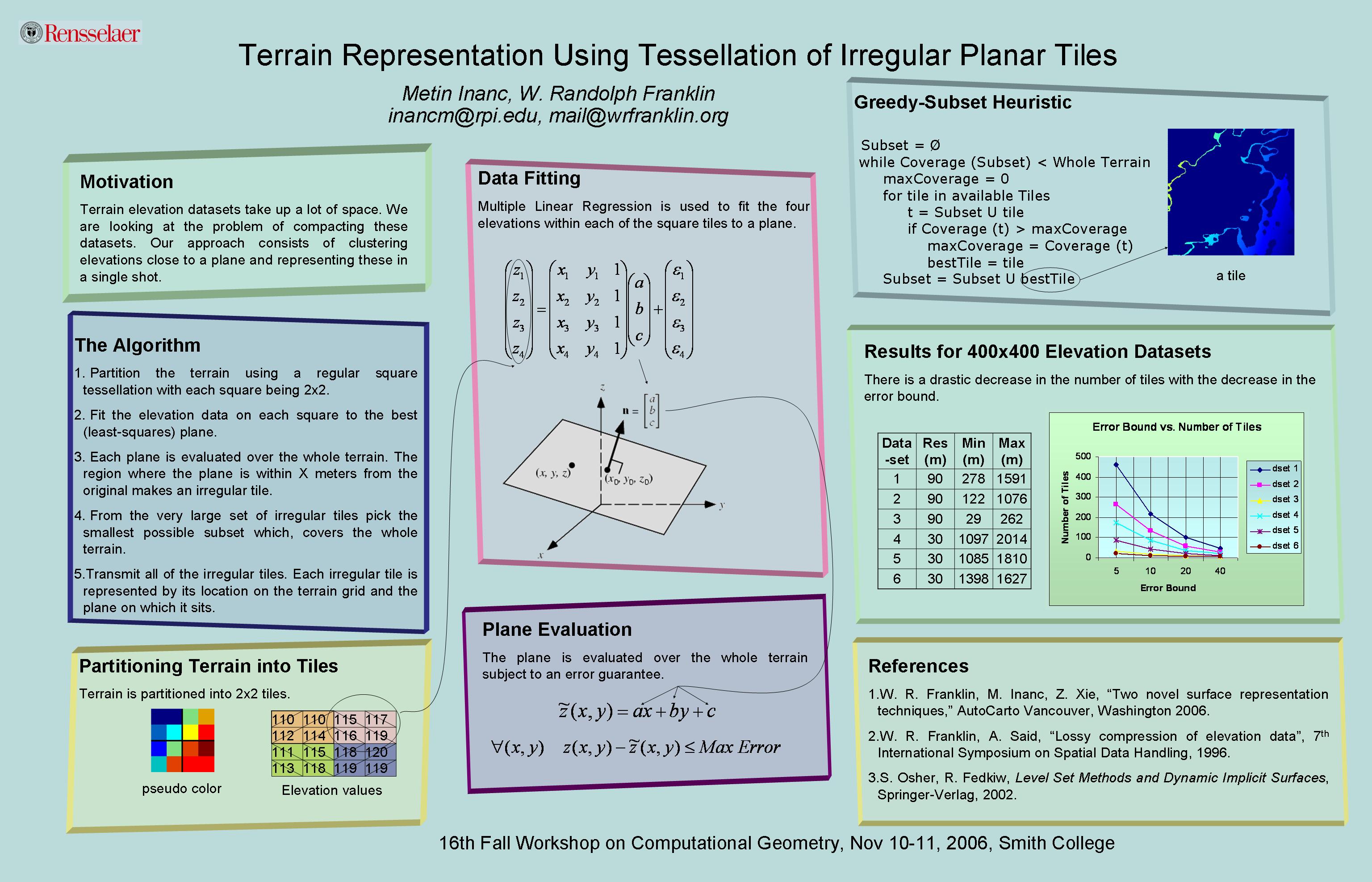
- Metin Inanc and W Randolph Franklin.
Terrain representation using tessellation of irregular planar tiles (extended abstract).
In 16th Fall Workshop on Computational Geometry. Smith College, Northampton MA, 10-11 Nov 2006.
[details] [full text] [poster] [BibTeX▼] - Caroline Westort and W. Randolph Franklin.
Alternative sculpting hypotheses for terrain data compression.
In Proceedings of SPIE Vol. 6313 Advanced Architectures, and Implementations XVI. San Diego CA, 15-16 August 2006. International Society for Optical Engineering.
6313-16, Session 4.
[abstract▼] [details] [BibTeX▼] - W. Randolph Franklin and Metin Inanc.
Compressing terrain datasets using segmentation.
In Proceedings of SPIE Vol. 6313 Advanced Architectures, and Implementations XVI. San Diego CA, 15-16 August 2006. International Society for Optical Engineering.
6313-17, Session 4.
[abstract▼] [details] [full text] [BibTeX▼] - W. Randolph Franklin, Metin Inanc, and Zhongyi Xie.
Two novel surface representation techniques.
In Autocarto 2006. Vancouver Washington, 25-28 June 2006. Cartography and Geographic Information Society, \url https://cartogis.org/autocarto/autocarto-2006/.
[details] [full text] [BibTeX▼]
2005
- Michael B. Gousie and Wm. Randolph Franklin.
Augmenting grid-based contours to improve thin plate dem generation.
Photogrammetric Engineering & Remote Sensing, 71(1):69–79, 2005.
[details] [full text] [BibTeX▼]
2003
- Michael Gousie and W. Randolph Franklin.
Constructing a DEM from grid-based data by computing intermediate contours.
In Erik Hoel and Phillippe Rigaux, editors, GIS 2003: Proceedings of the Eleventh ACM International Symposium on Advances in Geographic Information Systems, 71–77. New Orleans, 2003.
[details] [full text] [BibTeX▼]
1999
- W. Randolph Franklin and Michael Gousie.
Terrain elevation data structure operations.
In C. Peter Keller, editor, Proceedings of the 19th International Cartographic Association Conference, 1011–1020. Ottawa, August 1999.
URL: https://wrfranklin.org/wiki/Research/ica99/.
[details] [full text] [BibTeX▼]
1998
- Michael Gousie and W. Randolph Franklin.
Converting elevation contours to a grid.
In Eighth International Symposium on Spatial Data Handling, 647–656. Vancouver BC Canada, July 1998. Dept of Geography, Simon Fraser University, Burnaby, BC, Canada.
[details] [full text] [slides] [BibTeX▼]
Contact: WRF