2008
- Christopher Stuetzle, W. Randolph Franklin, Barbara Cutler, Jonathan Muckell, Marcus Andrade, Jared Stookey, Metin Inanc, and Zhongyi Xie.
Evaluating hydrology preservation of simplified terrain representations.
In Walid G. Aref and others, editors, 16th ACM SIGSPATIAL International Conference on Advances in Geographic Information Systems (ACM GIS 2008). Irvine CA, 5–7 Nov 2008.
(PhD student poster and fast forward presentation).
URL: http://acmgis08.cs.umn.edu/.
[details] [slides] [poster]
BibTeX
@inproceedings{muckell-acmgis-2008,
    author = "Stuetzle, Christopher and Franklin, W. Randolph and Cutler, Barbara and Muckell, Jonathan and Andrade, Marcus and Stookey, Jared and Inanc, Metin and Xie, Zhongyi",
    editor = "Aref, Walid G. and others",
    title = "Evaluating Hydrology Preservation of Simplified Terrain Representations",
    booktitle = "16th {ACM SIGSPATIAL} International Conference on Advances in Geographic Information Systems ({ACM GIS} 2008)",
    year = "2008",
    address = "Irvine CA",
    month = "5--7 Nov",
    mykey = "inanc muckell marcus xie terrain hydro",
    customlinkslides = "https://wrfranklin.org/p/125-acmgis2008-muckell-talk.ppt",
    customlinkposter = "https://wrfranklin.org/p/125-acmgis2008-muckell-poster.ppt",
    href = "\bibhreftp{125-acmgis2008-muckell-talk.ppt}{125-acmgis2008-muckell-poster.ppt}",
    note = "(PhD student poster and fast forward presentation)",
    url = "http://acmgis08.cs.umn.edu/"
}
- Zhongyi Xie, Marcus A. Andrade, W Randolph Franklin, Barbara Cutler, Metin Inanc, Jonathan Muckell, and Daniel M. Tracy.
Progressive transmission of lossily compressed terrain.
In CLEI 2008 Conferencia Latinoamericana de Informática. Santa Fe, Argentina, 8–12 Sep 2008.
[details] [full text]
BibTeX
@inproceedings{andrade-prog-trans-2008,
    author = "Xie, Zhongyi and Andrade, Marcus A. and Franklin, W Randolph and Cutler, Barbara and Inanc, Metin and Muckell, Jonathan and Tracy, Daniel M.",
    title = "Progressive Transmission of Lossily Compressed Terrain",
    booktitle = "{CLEI 2008} Conferencia Latinoamericana de Informática",
    year = "2008",
    address = "Santa Fe, Argentina",
    month = "8--12 Sep",
    href = "\bibhref{127-andrade-prog-trans-2008}",
    mykey = "marcus tracy inanc muckell xie terrain"
}
- Jonathan Muckell, Marcus Andrade, W. Randolph Franklin, Barbara Cutler, Metin Inanc, Zhongyi Xie, and Daniel M. Tracy.
Hydrology-aware constrained triangulation of terrain data.
(unpublished), Apr 2008.
[details] [full text]
BibTeX
@unpublished{muckell-HydroTIN-2008,
    author = "Muckell, Jonathan and Andrade, Marcus and Franklin, W. Randolph and Cutler, Barbara and Inanc, Metin and Xie, Zhongyi and Tracy, Daniel M.",
    title = "Hydrology-Aware Constrained Triangulation of Terrain Data",
    mykey = "inanc marcus muckell xie tracy hydro",
    href = "\bibhref{120-muckell-HydroTIN-2008}",
    note = "(unpublished)",
    month = "Apr",
    year = "2008"
}
- Jonathan Muckell, Marcus Andrade, W. Randolph Franklin, Barbara Cutler, Metin Inanc, Zhongyi Xie, and Daniel M. Tracy.
Evaluating hydrology preservation of simplified terrain representations.
(unpublished), Apr 2008.
[details] [full text]
BibTeX
@unpublished{muckell-HydroMetric-ODETLAP-2008,
    author = "Muckell, Jonathan and Andrade, Marcus and Franklin, W. Randolph and Cutler, Barbara and Inanc, Metin and Xie, Zhongyi and Tracy, Daniel M.",
    title = "Evaluating Hydrology Preservation of Simplified Terrain Representations",
    href = "\bibhref{121-muckell-HydroMetric-ODETLAP-2008}",
    note = "(unpublished)",
    month = "Apr",
    mykey = "odetlap tracy inanc marcus muckell xie hydro",
    year = "2008"
}
- W. Randolph Franklin, Daniel M. Tracy, Marcus Andrade, Jonathan Muckell, Metin Inanc, Zhongyi Xie, and Barbara Cutler.
Slope accuracy and path planning on compressed terrain.
In Symposium on Spatial Data Handling. Montpellier FR, June 2008.
[details] [full text]
BibTeX
@inproceedings{wrf-sdh-2008,
    author = "Franklin, W. Randolph and Tracy, Daniel M. and Andrade, Marcus and Muckell, Jonathan and Inanc, Metin and Xie, Zhongyi and Cutler, Barbara",
    title = "Slope Accuracy and Path Planning on Compressed Terrain",
    booktitle = "Symposium on Spatial Data Handling",
    year = "2008",
    month = "June",
    address = "Montpellier FR",
    mykey = "tracy inanc marcus muckell xie pathplan terrain",
    href = "\bibhref{119-sdh08-slope}"
}
- Metin Inanc.
Compressing Terrain Elevation Datasets.
PhD thesis, Rensselaer Polytechnic Institute, 2008.
[details] [full text]
BibTeX
@phdthesis{inanc-phd,
    author = "Inanc, Metin",
    title = "Compressing Terrain Elevation Datasets",
    school = "Rensselaer Polytechnic Institute",
    mykey = "theses odetlap inanc",
    year = "2008"
}
2007
- Zhongyi Xie, Marcus A. Andrade, W. Randolph Franklin, Barbara Cutler, Metin Inanc, Daniel M. Tracy, and Jonathan Muckell.
Approximating terrain with over-determined Laplacian PDEs.
In 17th Fall Workshop on Computational Geometry. IBM TJ Watson Research Center, Hawthorne NY, 2–3 Nov 2007.
(poster session, no formal proceedings).
[details] [full text] [poster]
BibTeX
@inproceedings{xie-fwcg-2007,
    author = "Xie, Zhongyi and Andrade, Marcus A. and Franklin, W. Randolph and Cutler, Barbara and Inanc, Metin and Tracy, Daniel M. and Muckell, Jonathan",
    title = "Approximating terrain with over-determined {Laplacian} {PDEs}",
    booktitle = "17th Fall Workshop on Computational Geometry",
    month = "2--3 Nov",
    mykey = "tracy inanc marcus xie muckell odetlap",
    year = "2007",
    note = "(poster session, no formal proceedings)",
    address = "IBM TJ Watson Research Center, Hawthorne NY",
    customlinkposter = "https://wrfranklin.org/p/117-fwcg07-xie-poster.ppt",
    href = "\bibhrefap{117-fwcg07-xie-abs}{117-fwcg07-xie-poster.ppt}"
}
- Jonathan Muckell, Marcus Andrade, W. Randolph Franklin, Barbara Cutler, Metin Inanc, Zhongyi Xie, and Daniel M. Tracy.
Drainage network and watershed reconstruction on simplified terrain.
In 17th Fall Workshop on Computational Geometry. IBM TJ Watson Research Center, Hawthorne NY, 2–3 Nov 2007.
poster session, no formal proceedings.
[details] [full text] [slides]
BibTeX
@inproceedings{muckell-fwcg-2007,
    author = "Muckell, Jonathan and Andrade, Marcus and Franklin, W. Randolph and Cutler, Barbara and Inanc, Metin and Xie, Zhongyi and Tracy, Daniel M.",
    title = "Drainage network and watershed reconstruction on simplified terrain",
    booktitle = "17th Fall Workshop on Computational Geometry",
    month = "2--3 Nov",
    year = "2007",
    note = "poster session, no formal proceedings",
    address = "IBM TJ Watson Research Center, Hawthorne NY",
    customlinkslides = "https://wrfranklin.org/p/116-fwcg07-muckell-poster.ppt",
    mykey = "tracy marcus inanc muckell xie hydro",
    href = "\bibhrefap{116-fwcg07-muckell-abs}{116-fwcg07-muckell-poster.ppt}"
}
- W Randolph Franklin, Metin Inanc, Zhongyi Xie, Daniel M. Tracy, Barbara Cutler, Marcus V A Andrade, and Franklin Luk.
Smugglers and border guards – the GeoStar project at RPI.
In 15th ACM International Symposium on Advances in Geographic Information Systems (ACM GIS 2007). Seattle, WA, USA, Nov 2007.
[details] [full text] [slides]
Abstract
We present the GeoStar project at RPI, which researches various terrain (i.e., elevation) representations and operations thereon. This work is motivated by the large amounts of hi-res data now available. The purpose of each representation is to lossily compress terrain while maintaining important properties. Our ODETLAP representation generalizes a Laplacian partial differential equation by using two inconsistent equations for each known point in the grid, as well as one equation for each unknown point. The surface is reconstructed from a carefully chosen small set of known points. Our second representation segments the terrain intoa set of regions, each of which is simply described. Our third representation has the most long term potential: scooping, which forms the terrain by emulating surface water erosion. Siting hundreds of observers, such as border guards, so that their viewsheds jointly cover the maximum terrain is our first operation. This process allows both observer and target to be above the local terrain, and the observer to have a finite radius of interest. Planning a path so that a smuggler may get from point A to point B while maximally avoiding the border guards is our second operation. The path metric includes path length, distance traveled uphill,and amount of time visible to a guard. The quality of our representations is determined, not only by their RMS elevation error, but by how accurately they support these operations.
BibTeX
@inproceedings{acmgis07,
    author = "Franklin, W Randolph and Inanc, Metin and Xie, Zhongyi and Tracy, Daniel M. and Cutler, Barbara and Andrade, Marcus V A and Luk, Franklin",
    title = "Smugglers and border guards -- the {GeoStar} project at {RPI}",
    booktitle = "15th {ACM} International Symposium on Advances in Geographic Information Systems {(ACM GIS 2007)}",
    year = "2007",
    address = "Seattle, WA, USA",
    month = "Nov",
    customlinkslides = "https://wrfranklin.org/p/115-seattle07-acmgis-smugglers-talk.ppt",
    mykey = "pathplan visviewshedsiting marcus tracy inanc xie",
    href = "\bibhrefpt{115-seattle07-acmgis-smugglers}{115-seattle07-acmgis-smugglers-talk.ppt}"
}
- Daniel M. Tracy, W. Randolph Franklin, Barbara Cutler, Marcus A Andrade, Franklin T Luk, Metin Inanc, and Zhongyi Xie.
Multiple observer siting and path planning on lossily compressed terrain.
In Proceedings of SPIE Vol. 6697 Advanced Signal Processing Algorithms, Architectures, and Implementations XVII. San Diego CA, 27 August 2007. International Society for Optical Engineering.
paper 6697-16.
[details] [full text]
Abstract
We examine a smugglers and border guards scenario. We place observers on a terrain so as to optimize their visible coverage area. Then we compute a path that a smuggler would take so as to avoid detection, while also minimizing the path length. We also examine how our results are affected by using a lossy representation of the terrain instead. We propose three new application-specific error metrics for evaluating terrain compression. Our target terrain applications are the optimal placement of observers on a landscape and the navigation through the terrain by smugglers. Instead of using standard metrics such as average or maximum elevation error, we seek to optimize our compression on the specific real-world application of smugglers and border guards.
BibTeX
@inproceedings{dt-wrf-spie-2007,
    author = "Tracy, Daniel M. and Franklin, W. Randolph and Cutler, Barbara and Andrade, Marcus A and Luk, Franklin T and Inanc, Metin and Xie, Zhongyi",
    title = "Multiple observer siting and path planning on lossily compressed terrain",
    booktitle = "Proceedings of {SPIE} Vol. 6697 Advanced Signal Processing Algorithms, Architectures, and Implementations {XVII}",
    year = "2007",
    month = "27 August",
    organization = "International Society for Optical Engineering",
    address = "San Diego CA",
    note = "paper 6697-16",
    mykey = "inanc tracy marcus xie pathplan visviewshedsiting",
    href = "\bibhref{114-spie07-tracy}"
}
- Zhongyi Xie, W. Randolph Franklin, Barbara Cutler, Marcus A Andrade, Metin Inanc, and Daniel M. Tracy.
Surface compression using over-determined Laplacian approximation.
In Proceedings of SPIE Vol. 6697 Advanced Signal Processing Algorithms, Architectures, and Implementations XVII. San Diego CA, 27 August 2007. International Society for Optical Engineering.
paper 6697-15.
[details] [full text]
Abstract
BibTeX
@inproceedings{zx-wrf-spie-2007,
    author = "Xie, Zhongyi and Franklin, W. Randolph and Cutler, Barbara and Andrade, Marcus A and Inanc, Metin and Tracy, Daniel M.",
    title = "Surface compression using over-determined {Laplacian} approximation",
    booktitle = "Proceedings of {SPIE} Vol. 6697 Advanced Signal Processing Algorithms, Architectures, and Implementations {XVII}",
    year = "2007",
    month = "27 August",
    organization = "International Society for Optical Engineering",
    address = "San Diego CA",
    note = "paper 6697-15",
    href = "\bibhref{113-spie07-xie}",
    mykey = "marcus inanc xie odetlap"
}
2006
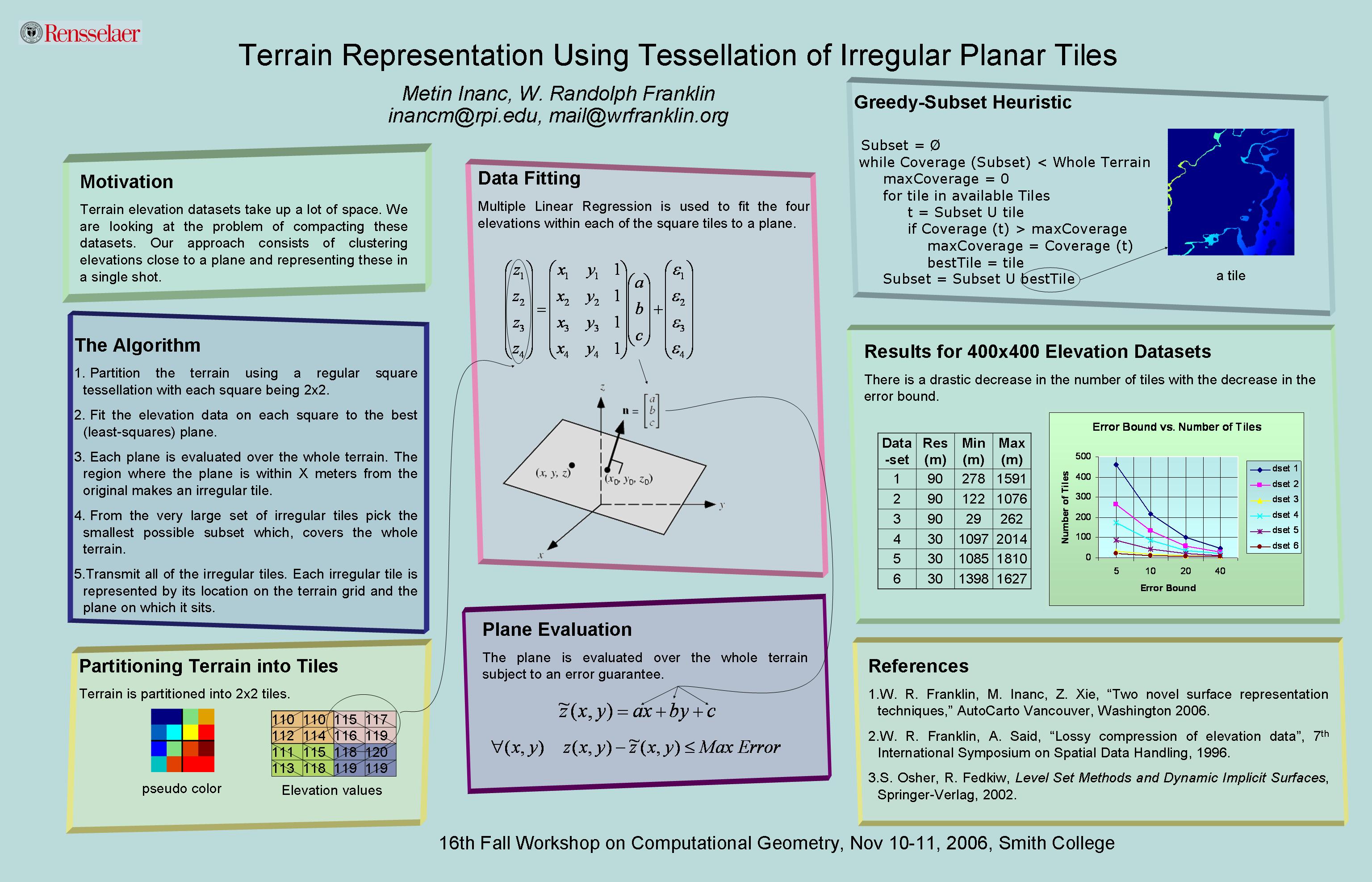
- Metin Inanc and W Randolph Franklin.
Terrain representation using tessellation of irregular planar tiles (extended abstract).
In 16th Fall Workshop on Computational Geometry. Smith College, Northampton MA, 10-11 Nov 2006.
[details] [full text] [poster]
BibTeX
@inproceedings{inanc-fwcg-2006,
    author = "Inanc, Metin and Franklin, W Randolph",
    title = "Terrain Representation Using Tessellation of Irregular Planar Tiles (extended abstract)",
    booktitle = "16th Fall Workshop on Computational Geometry",
    year = "2006",
    month = "10-11 Nov",
    address = "Smith College, Northampton MA",
    customlinkposter = "https://wrfranklin.org/p/108-smith-fwcg06-tiles-inanc-poster.jpg",
    href = "\bibhrefap{108-smith-fwcg06-tiles-inanc-abs}{108-smith-fwcg06-tiles-inanc-poster.jpg}",
    mykey = "inanc terrain"
}
- W. Randolph Franklin and Metin Inanc.
Compressing terrain datasets using segmentation.
In Proceedings of SPIE Vol. 6313 Advanced Architectures, and Implementations XVI. San Diego CA, 15-16 August 2006. International Society for Optical Engineering.
6313-17, Session 4.
[details] [full text]
Abstract
We propose a novel compression scheme to achieve lossless compression of elevation datasets. Our scheme does not use predictors in traditional sense. Predictors are based on dataset segments instead of the rows and columns processed so far. We believe that this is a far better way of expressing context in an image or elevation datasets since it can capture continuities in different geometries and is not limited to a subset of a pixel~s neighborhood. We compare the compression results of our scheme with that of JPEG-2000.
BibTeX
@inproceedings{wrf-mi-spie-2006,
    author = "Franklin, W. Randolph and Inanc, Metin",
    title = "Compressing terrain datasets using segmentation",
    booktitle = "Proceedings of {SPIE} Vol. 6313 Advanced Architectures, and Implementations {XVI}",
    year = "2006",
    month = "15-16 August",
    organization = "International Society for Optical Engineering",
    address = "San Diego CA",
    note = "6313-17, Session 4",
    mykey = "terrain inanc",
    href = "\bibhref{112b-spie06-inanc}"
}
- W. Randolph Franklin, Metin Inanc, and Zhongyi Xie.
Two novel surface representation techniques.
In Autocarto 2006. Vancouver Washington, 25-28 June 2006. Cartography and Geographic Information Society, \url https://cartogis.org/autocarto/autocarto-2006/.
[details] [full text]
BibTeX
@inproceedings{wrf-autocarto-2006,
    author = "Franklin, W. Randolph and Inanc, Metin and Xie, Zhongyi",
    title = "Two novel surface representation techniques",
    booktitle = "Autocarto 2006",
    year = "2006",
    address = "Vancouver Washington",
    month = "25-28 June",
    organization = "Cartography and Geographic Information Society, \url{https://cartogis.org/autocarto/autocarto-2006/}",
    mykey = "inanc xie terrain",
    href = "\bibhref{111-vancouverwa-autocarto06-twonovel}"
}
No publications match your search. Try another word or clear the search.